You are here: Home > Network List > TA - USArray Transportable Network (new EarthScope stations) Stations List
> Station D37A Cotton, MN, USA > Earthquake Result Viewer
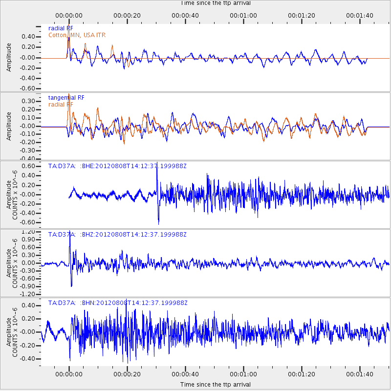
D37A Cotton, MN, USA - Earthquake Result Viewer
*The percent match for this event was below the threshold and hence no stack was calculated.
| Earthquake location: |
Alaska Peninsula |
| Earthquake latitude/longitude: |
54.9/-161.2 |
| Earthquake time(UTC): |
2012/08/08 (221) 14:05:17 GMT |
| Earthquake Depth: |
43 km |
| Earthquake Magnitude: |
5.6 MB, 5.2 MW, 5.1 MW |
| Earthquake Catalog/Contributor: |
WHDF/NEIC |
|
| Network: |
TA USArray Transportable Network (new EarthScope stations) |
| Station: |
D37A Cotton, MN, USA |
| Lat/Lon: |
47.16 N/92.43 W |
| Elevation: |
413 m |
|
| Distance: |
42.3 deg |
| Az: |
70.854 deg |
| Baz: |
306.876 deg |
| Ray Param: |
$rayparam |
*The percent match for this event was below the threshold and hence was not used in the summary stack. |
|
| Radial Match: |
56.544964 % |
| Radial Bump: |
400 |
| Transverse Match: |
60.793835 % |
| Transverse Bump: |
400 |
| SOD ConfigId: |
469095 |
| Insert Time: |
2013-02-22 04:56:10.243 +0000 |
| GWidth: |
2.5 |
| Max Bumps: |
400 |
| Tol: |
0.001 |
|
Signal To Noise
| Channel | StoN | STA | LTA |
| TA:D37A: :BHZ:20120808T14:12:37.199988Z | 7.4501667 | 3.698856E-7 | 4.9647962E-8 |
| TA:D37A: :BHN:20120808T14:12:37.199988Z | 3.1291687 | 1.6326804E-7 | 5.217617E-8 |
| TA:D37A: :BHE:20120808T14:12:37.199988Z | 3.8271189 | 1.9903842E-7 | 5.200738E-8 |
| Arrivals |
| Ps | |
| PpPs | |
| PsPs/PpSs | |


