You are here: Home > Network List > TA - USArray Transportable Network (new EarthScope stations) Stations List
> Station I37A Lemond, Waseca, MN, USA > Earthquake Result Viewer
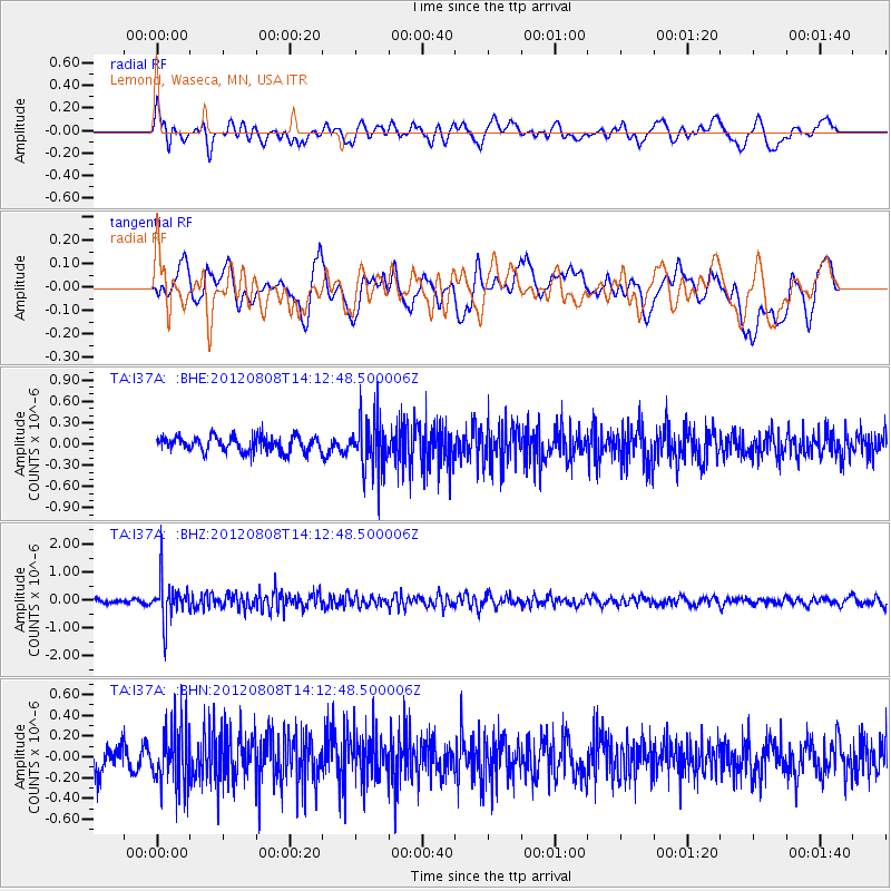
I37A Lemond, Waseca, MN, USA - Earthquake Result Viewer
*The percent match for this event was below the threshold and hence no stack was calculated.
| Earthquake location: |
Alaska Peninsula |
| Earthquake latitude/longitude: |
54.9/-161.2 |
| Earthquake time(UTC): |
2012/08/08 (221) 14:05:17 GMT |
| Earthquake Depth: |
43 km |
| Earthquake Magnitude: |
5.6 MB, 5.2 MW, 5.1 MW |
| Earthquake Catalog/Contributor: |
WHDF/NEIC |
|
| Network: |
TA USArray Transportable Network (new EarthScope stations) |
| Station: |
I37A Lemond, Waseca, MN, USA |
| Lat/Lon: |
44.01 N/93.40 W |
| Elevation: |
371 m |
|
| Distance: |
43.7 deg |
| Az: |
75.099 deg |
| Baz: |
309.286 deg |
| Ray Param: |
$rayparam |
*The percent match for this event was below the threshold and hence was not used in the summary stack. |
|
| Radial Match: |
60.27788 % |
| Radial Bump: |
400 |
| Transverse Match: |
49.755314 % |
| Transverse Bump: |
400 |
| SOD ConfigId: |
469095 |
| Insert Time: |
2013-02-22 04:56:59.917 +0000 |
| GWidth: |
2.5 |
| Max Bumps: |
400 |
| Tol: |
0.001 |
|
Signal To Noise
| Channel | StoN | STA | LTA |
| TA:I37A: :BHZ:20120808T14:12:48.500006Z | 7.2210073 | 7.3291807E-7 | 1.0149804E-7 |
| TA:I37A: :BHN:20120808T14:12:48.500006Z | 2.4416034 | 2.9194285E-7 | 1.1957013E-7 |
| TA:I37A: :BHE:20120808T14:12:48.500006Z | 3.4120007 | 3.659946E-7 | 1.0726686E-7 |
| Arrivals |
| Ps | |
| PpPs | |
| PsPs/PpSs | |


