You are here: Home > Network List > TA - USArray Transportable Network (new EarthScope stations) Stations List
> Station Y47A UCPARC, Winfield, AL, USA > Earthquake Result Viewer
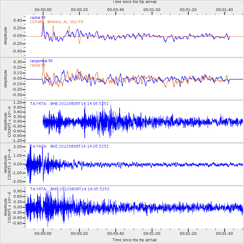
Y47A UCPARC, Winfield, AL, USA - Earthquake Result Viewer
*The percent match for this event was below the threshold and hence no stack was calculated.
| Earthquake location: |
Alaska Peninsula |
| Earthquake latitude/longitude: |
54.9/-161.2 |
| Earthquake time(UTC): |
2012/08/08 (221) 14:05:17 GMT |
| Earthquake Depth: |
43 km |
| Earthquake Magnitude: |
5.6 MB, 5.2 MW, 5.1 MW |
| Earthquake Catalog/Contributor: |
WHDF/NEIC |
|
| Network: |
TA USArray Transportable Network (new EarthScope stations) |
| Station: |
Y47A UCPARC, Winfield, AL, USA |
| Lat/Lon: |
33.90 N/87.85 W |
| Elevation: |
160 m |
|
| Distance: |
53.8 deg |
| Az: |
80.98 deg |
| Baz: |
316.671 deg |
| Ray Param: |
$rayparam |
*The percent match for this event was below the threshold and hence was not used in the summary stack. |
|
| Radial Match: |
68.2051 % |
| Radial Bump: |
400 |
| Transverse Match: |
55.200108 % |
| Transverse Bump: |
400 |
| SOD ConfigId: |
469095 |
| Insert Time: |
2013-02-22 05:02:51.329 +0000 |
| GWidth: |
2.5 |
| Max Bumps: |
400 |
| Tol: |
0.001 |
|
Signal To Noise
| Channel | StoN | STA | LTA |
| TA:Y47A: :BHZ:20120808T14:14:05.525Z | 1.4050407 | 6.739842E-7 | 4.7969013E-7 |
| TA:Y47A: :BHN:20120808T14:14:05.525Z | 1.3576344 | 3.866392E-7 | 2.8478888E-7 |
| TA:Y47A: :BHE:20120808T14:14:05.525Z | 1.6515099 | 3.7969718E-7 | 2.2990912E-7 |
| Arrivals |
| Ps | |
| PpPs | |
| PsPs/PpSs | |


