You are here: Home > Network List > TA - USArray Transportable Network (new EarthScope stations) Stations List
> Station U41A Viola, AR, USA > Earthquake Result Viewer
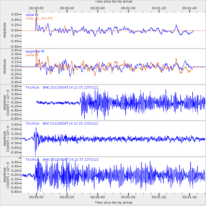
U41A Viola, AR, USA - Earthquake Result Viewer
*The percent match for this event was below the threshold and hence no stack was calculated.
| Earthquake location: |
Alaska Peninsula |
| Earthquake latitude/longitude: |
54.9/-161.2 |
| Earthquake time(UTC): |
2012/08/08 (221) 14:05:17 GMT |
| Earthquake Depth: |
43 km |
| Earthquake Magnitude: |
5.6 MB, 5.2 MW, 5.1 MW |
| Earthquake Catalog/Contributor: |
WHDF/NEIC |
|
| Network: |
TA USArray Transportable Network (new EarthScope stations) |
| Station: |
U41A Viola, AR, USA |
| Lat/Lon: |
36.34 N/91.92 W |
| Elevation: |
300 m |
|
| Distance: |
49.7 deg |
| Az: |
81.863 deg |
| Baz: |
314.885 deg |
| Ray Param: |
$rayparam |
*The percent match for this event was below the threshold and hence was not used in the summary stack. |
|
| Radial Match: |
51.299362 % |
| Radial Bump: |
400 |
| Transverse Match: |
53.785088 % |
| Transverse Bump: |
400 |
| SOD ConfigId: |
469095 |
| Insert Time: |
2013-02-22 05:06:29.355 +0000 |
| GWidth: |
2.5 |
| Max Bumps: |
400 |
| Tol: |
0.001 |
|
Signal To Noise
| Channel | StoN | STA | LTA |
| TA:U41A: :BHZ:20120808T14:13:35.225012Z | 6.4881525 | 3.1353972E-7 | 4.8324964E-8 |
| TA:U41A: :BHN:20120808T14:13:35.225012Z | 8.352464 | 3.7228784E-7 | 4.457222E-8 |
| TA:U41A: :BHE:20120808T14:13:35.225012Z | 8.46334 | 2.9135472E-7 | 3.44255E-8 |
| Arrivals |
| Ps | |
| PpPs | |
| PsPs/PpSs | |


