You are here: Home > Network List > TA - USArray Transportable Network (new EarthScope stations) Stations List
> Station E39A Mellen, WI, USA > Earthquake Result Viewer
E39A Mellen, WI, USA - Earthquake Result Viewer
*The percent match for this event was below the threshold and hence no stack was calculated.
| Earthquake location: |
Alaska Peninsula |
| Earthquake latitude/longitude: |
54.9/-161.2 |
| Earthquake time(UTC): |
2012/08/08 (221) 14:05:17 GMT |
| Earthquake Depth: |
43 km |
| Earthquake Magnitude: |
5.6 MB, 5.2 MW, 5.1 MW |
| Earthquake Catalog/Contributor: |
WHDF/NEIC |
|
| Network: |
TA USArray Transportable Network (new EarthScope stations) |
| Station: |
E39A Mellen, WI, USA |
| Lat/Lon: |
46.38 N/90.56 W |
| Elevation: |
426 m |
|
| Distance: |
43.8 deg |
| Az: |
70.616 deg |
| Baz: |
308.061 deg |
| Ray Param: |
$rayparam |
*The percent match for this event was below the threshold and hence was not used in the summary stack. |
|
| Radial Match: |
53.772858 % |
| Radial Bump: |
400 |
| Transverse Match: |
48.5735 % |
| Transverse Bump: |
400 |
| SOD ConfigId: |
469095 |
| Insert Time: |
2013-02-22 05:09:49.508 +0000 |
| GWidth: |
2.5 |
| Max Bumps: |
400 |
| Tol: |
0.001 |
|
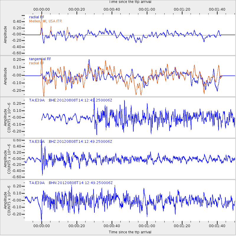
Signal To Noise
| Channel | StoN | STA | LTA |
| TA:E39A: :BHZ:20120808T14:12:49.250006Z | 4.040861 | 2.248189E-7 | 5.563638E-8 |
| TA:E39A: :BHN:20120808T14:12:49.250006Z | 1.9458365 | 1.0079813E-7 | 5.180195E-8 |
| TA:E39A: :BHE:20120808T14:12:49.250006Z | 2.6773214 | 9.4762825E-8 | 3.539464E-8 |
| Arrivals |
| Ps | |
| PpPs | |
| PsPs/PpSs | |


