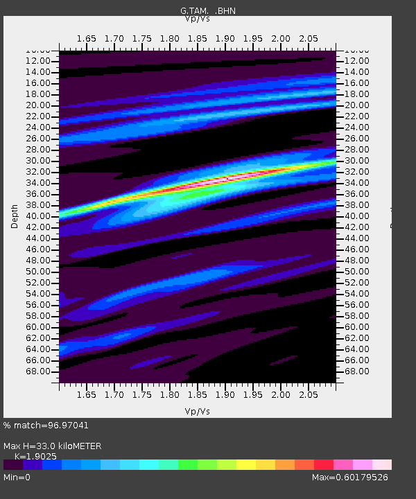
TAM Tamanrasset, Algeria - Earthquake Result Viewer
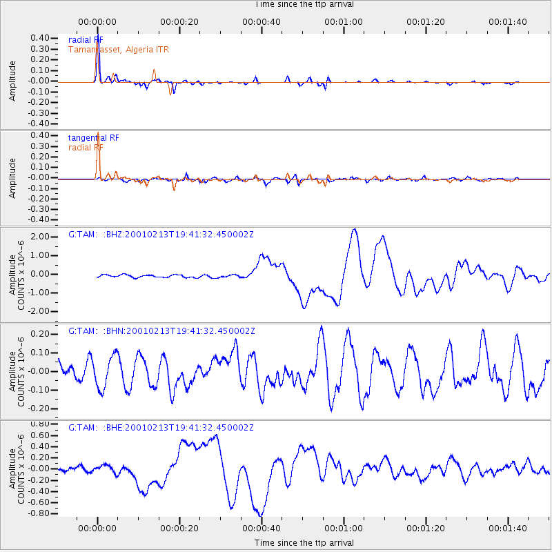
Earthquake location: Southern Sumatra, Indonesia
Earthquake latitude/longitude: -4.7/102.6
Earthquake time(UTC): 2001/02/13 (044) 19:28:30 GMT
Earthquake Depth: 36 km
Earthquake Magnitude: 6.2 MB, 7.2 MS, 7.4 MW, 7.0 ME
Earthquake Catalog/Contributor: WHDF/NEIC
Network: G GEOSCOPE
Station: TAM Tamanrasset, Algeria
Lat/Lon: 22.79 N/5.53 E
Elevation: 1377 m
Distance: 98.3 deg
Az: 292.252 deg
Baz: 91.608 deg
Ray Param: 0.03993459
Estimated Moho Depth: 33.0 km
Estimated Crust Vp/Vs: 1.90
Assumed Crust Vp: 6.61 km/s
Estimated Crust Vs: 3.474 km/s
Estimated Crust Poisson's Ratio: 0.31
Radial Match: 96.97041 %
Radial Bump: 209
Transverse Match: 72.21982 %
Transverse Bump: 400
SOD ConfigId: 3744
Insert Time: 2010-02-27 00:33:04.289 +0000
GWidth: 2.5
Max Bumps: 400
Tol: 0.001

Signal To Noise

ChannelStoNSTALTA
G:TAM: :BHN:20010213T19:41:32.450002Z1.92310818.711524E-84.529919E-8
G:TAM: :BHE:20010213T19:41:32.450002Z1.57610266.918924E-84.3898943E-8
G:TAM: :BHZ:20010213T19:41:32.450002Z0.930390546.562669E-87.053672E-8
Arrivals
Ps4.6 SECOND
PpPs14 SECOND
PsPs/PpSs19 SECOND