You are here: Home > Network List > G - GEOSCOPE Stations List
> Station TAM Tamanrasset, Algeria > Earthquake Result Viewer
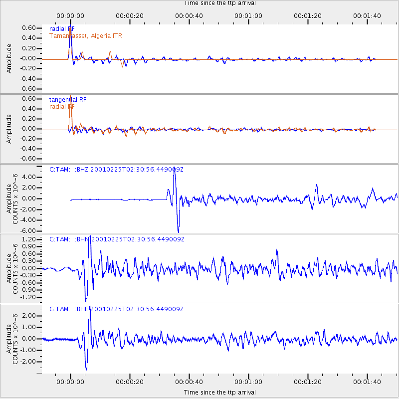
TAM Tamanrasset, Algeria - Earthquake Result Viewer

| Earthquake location: |
Hindu Kush Region, Afghanistan |
| Earthquake latitude/longitude: |
36.4/70.9 |
| Earthquake time(UTC): |
2001/02/25 (056) 02:21:59 GMT |
| Earthquake Depth: |
202 km |
| Earthquake Magnitude: |
5.8 MB, 6.3 MW, 6.1 MW |
| Earthquake Catalog/Contributor: |
WHDF/NEIC |
|
| Network: |
G GEOSCOPE |
| Station: |
TAM Tamanrasset, Algeria |
| Lat/Lon: |
22.79 N/5.53 E |
| Elevation: |
1377 m |
|
| Distance: |
57.4 deg |
| Az: |
275.661 deg |
| Baz: |
60.425 deg |
| Ray Param: |
0.062820464 |
| Estimated Moho Depth: |
23.0 km |
| Estimated Crust Vp/Vs: |
1.99 |
| Assumed Crust Vp: |
6.61 km/s |
| Estimated Crust Vs: |
3.33 km/s |
| Estimated Crust Poisson's Ratio: |
0.33 |
|
| Radial Match: |
96.434105 % |
| Radial Bump: |
248 |
| Transverse Match: |
75.18257 % |
| Transverse Bump: |
400 |
| SOD ConfigId: |
3744 |
| Insert Time: |
2010-02-27 00:33:05.904 +0000 |
| GWidth: |
2.5 |
| Max Bumps: |
400 |
| Tol: |
0.001 |
|
Signal To Noise
| Channel | StoN | STA | LTA |
| G:TAM: :BHN:20010225T02:30:56.449009Z | 5.90278 | 2.0837537E-7 | 3.5301227E-8 |
| G:TAM: :BHE:20010225T02:30:56.449009Z | 9.176681 | 3.4978277E-7 | 3.811648E-8 |
| G:TAM: :BHZ:20010225T02:30:56.449009Z | 20.04373 | 1.0448606E-6 | 5.2129053E-8 |
| Arrivals |
| Ps | 3.6 SECOND |
| PpPs | 9.9 SECOND |
| PsPs/PpSs | 14 SECOND |


