You are here: Home > Network List > TA - USArray Transportable Network (new EarthScope stations) Stations List
> Station P47A Martinsville, IN, USA > Earthquake Result Viewer
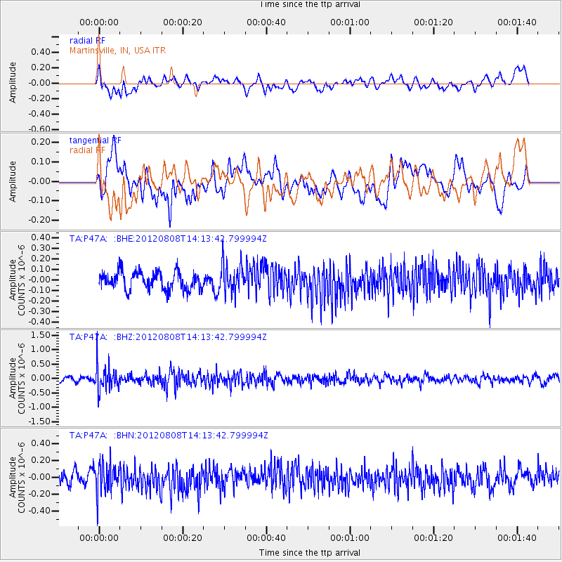
P47A Martinsville, IN, USA - Earthquake Result Viewer
*The percent match for this event was below the threshold and hence no stack was calculated.
| Earthquake location: |
Alaska Peninsula |
| Earthquake latitude/longitude: |
54.9/-161.2 |
| Earthquake time(UTC): |
2012/08/08 (221) 14:05:17 GMT |
| Earthquake Depth: |
43 km |
| Earthquake Magnitude: |
5.6 MB, 5.2 MW, 5.1 MW |
| Earthquake Catalog/Contributor: |
WHDF/NEIC |
|
| Network: |
TA USArray Transportable Network (new EarthScope stations) |
| Station: |
P47A Martinsville, IN, USA |
| Lat/Lon: |
39.49 N/86.27 W |
| Elevation: |
246 m |
|
| Distance: |
50.7 deg |
| Az: |
74.878 deg |
| Baz: |
313.874 deg |
| Ray Param: |
$rayparam |
*The percent match for this event was below the threshold and hence was not used in the summary stack. |
|
| Radial Match: |
56.504223 % |
| Radial Bump: |
400 |
| Transverse Match: |
51.695007 % |
| Transverse Bump: |
400 |
| SOD ConfigId: |
469095 |
| Insert Time: |
2013-02-22 05:12:30.284 +0000 |
| GWidth: |
2.5 |
| Max Bumps: |
400 |
| Tol: |
0.001 |
|
Signal To Noise
| Channel | StoN | STA | LTA |
| TA:P47A: :BHZ:20120808T14:13:42.799994Z | 5.26994 | 4.3018136E-7 | 8.1629274E-8 |
| TA:P47A: :BHN:20120808T14:13:42.799994Z | 2.3592434 | 1.7448548E-7 | 7.395823E-8 |
| TA:P47A: :BHE:20120808T14:13:42.799994Z | 1.6518104 | 1.3718788E-7 | 8.305305E-8 |
| Arrivals |
| Ps | |
| PpPs | |
| PsPs/PpSs | |


