You are here: Home > Network List > TA - USArray Transportable Network (new EarthScope stations) Stations List
> Station A33A Warroad, MN, USA > Earthquake Result Viewer
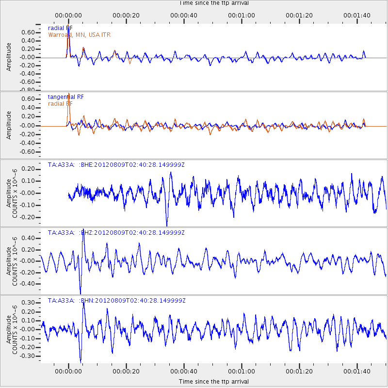
A33A Warroad, MN, USA - Earthquake Result Viewer
*The percent match for this event was below the threshold and hence no stack was calculated.
| Earthquake location: |
Revilla Gigedo Islands Region |
| Earthquake latitude/longitude: |
19.9/-109.3 |
| Earthquake time(UTC): |
2012/08/09 (222) 02:34:41 GMT |
| Earthquake Depth: |
10 km |
| Earthquake Magnitude: |
5.6 MW, 5.0 MS, 5.1 MB, 5.5 MW |
| Earthquake Catalog/Contributor: |
WHDF/NEIC |
|
| Network: |
TA USArray Transportable Network (new EarthScope stations) |
| Station: |
A33A Warroad, MN, USA |
| Lat/Lon: |
48.94 N/95.39 W |
| Elevation: |
329 m |
|
| Distance: |
31.0 deg |
| Az: |
17.956 deg |
| Baz: |
206.093 deg |
| Ray Param: |
$rayparam |
*The percent match for this event was below the threshold and hence was not used in the summary stack. |
|
| Radial Match: |
75.54412 % |
| Radial Bump: |
352 |
| Transverse Match: |
65.372734 % |
| Transverse Bump: |
371 |
| SOD ConfigId: |
469095 |
| Insert Time: |
2013-02-22 05:30:13.899 +0000 |
| GWidth: |
2.5 |
| Max Bumps: |
400 |
| Tol: |
0.001 |
|
Signal To Noise
| Channel | StoN | STA | LTA |
| TA:A33A: :BHZ:20120809T02:40:28.149999Z | 2.7777212 | 1.9290502E-7 | 6.9447225E-8 |
| TA:A33A: :BHN:20120809T02:40:28.149999Z | 2.3681767 | 1.1648679E-7 | 4.9188383E-8 |
| TA:A33A: :BHE:20120809T02:40:28.149999Z | 2.5912797 | 9.718311E-8 | 3.7503906E-8 |
| Arrivals |
| Ps | |
| PpPs | |
| PsPs/PpSs | |


