You are here: Home > Network List > TA - USArray Transportable Network (new EarthScope stations) Stations List
> Station N59A State Game Land 141, Hazleton, PA, USA > Earthquake Result Viewer
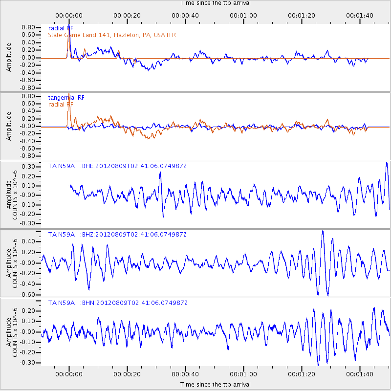
N59A State Game Land 141, Hazleton, PA, USA - Earthquake Result Viewer
*The percent match for this event was below the threshold and hence no stack was calculated.
| Earthquake location: |
Revilla Gigedo Islands Region |
| Earthquake latitude/longitude: |
19.9/-109.3 |
| Earthquake time(UTC): |
2012/08/09 (222) 02:34:41 GMT |
| Earthquake Depth: |
10 km |
| Earthquake Magnitude: |
5.6 MW, 5.0 MS, 5.1 MB, 5.5 MW |
| Earthquake Catalog/Contributor: |
WHDF/NEIC |
|
| Network: |
TA USArray Transportable Network (new EarthScope stations) |
| Station: |
N59A State Game Land 141, Hazleton, PA, USA |
| Lat/Lon: |
40.92 N/75.77 W |
| Elevation: |
508 m |
|
| Distance: |
35.4 deg |
| Az: |
46.352 deg |
| Baz: |
243.928 deg |
| Ray Param: |
$rayparam |
*The percent match for this event was below the threshold and hence was not used in the summary stack. |
|
| Radial Match: |
69.88453 % |
| Radial Bump: |
400 |
| Transverse Match: |
60.135002 % |
| Transverse Bump: |
400 |
| SOD ConfigId: |
469095 |
| Insert Time: |
2013-02-22 05:30:28.312 +0000 |
| GWidth: |
2.5 |
| Max Bumps: |
400 |
| Tol: |
0.001 |
|
Signal To Noise
| Channel | StoN | STA | LTA |
| TA:N59A: :BHZ:20120809T02:41:06.074987Z | 3.2488618 | 2.0320205E-7 | 6.254561E-8 |
| TA:N59A: :BHN:20120809T02:41:06.074987Z | 0.9466116 | 4.4200252E-8 | 4.6693128E-8 |
| TA:N59A: :BHE:20120809T02:41:06.074987Z | 2.0932457 | 1.0878125E-7 | 5.196774E-8 |
| Arrivals |
| Ps | |
| PpPs | |
| PsPs/PpSs | |


