You are here: Home > Network List > TA - USArray Transportable Network (new EarthScope stations) Stations List
> Station E38A The Farm, Brule, WI, USA > Earthquake Result Viewer
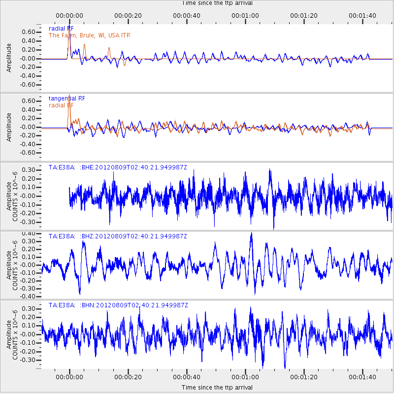
E38A The Farm, Brule, WI, USA - Earthquake Result Viewer
*The percent match for this event was below the threshold and hence no stack was calculated.
| Earthquake location: |
Revilla Gigedo Islands Region |
| Earthquake latitude/longitude: |
19.9/-109.3 |
| Earthquake time(UTC): |
2012/08/09 (222) 02:34:41 GMT |
| Earthquake Depth: |
10 km |
| Earthquake Magnitude: |
5.6 MW, 5.0 MS, 5.1 MB, 5.5 MW |
| Earthquake Catalog/Contributor: |
WHDF/NEIC |
|
| Network: |
TA USArray Transportable Network (new EarthScope stations) |
| Station: |
E38A The Farm, Brule, WI, USA |
| Lat/Lon: |
46.61 N/91.55 W |
| Elevation: |
341 m |
|
| Distance: |
30.3 deg |
| Az: |
24.648 deg |
| Baz: |
214.683 deg |
| Ray Param: |
$rayparam |
*The percent match for this event was below the threshold and hence was not used in the summary stack. |
|
| Radial Match: |
68.02912 % |
| Radial Bump: |
400 |
| Transverse Match: |
48.022484 % |
| Transverse Bump: |
400 |
| SOD ConfigId: |
469095 |
| Insert Time: |
2013-02-22 05:30:40.528 +0000 |
| GWidth: |
2.5 |
| Max Bumps: |
400 |
| Tol: |
0.001 |
|
Signal To Noise
| Channel | StoN | STA | LTA |
| TA:E38A: :BHZ:20120809T02:40:21.949987Z | 2.6710691 | 1.7094156E-7 | 6.399743E-8 |
| TA:E38A: :BHN:20120809T02:40:21.949987Z | 1.1295385 | 7.7856924E-8 | 6.892808E-8 |
| TA:E38A: :BHE:20120809T02:40:21.949987Z | 0.9490506 | 7.107805E-8 | 7.489385E-8 |
| Arrivals |
| Ps | |
| PpPs | |
| PsPs/PpSs | |


