You are here: Home > Network List > TA - USArray Transportable Network (new EarthScope stations) Stations List
> Station N50A Nevada, OH, USA > Earthquake Result Viewer
N50A Nevada, OH, USA - Earthquake Result Viewer
| Earthquake location: |
Revilla Gigedo Islands Region |
| Earthquake latitude/longitude: |
19.9/-109.3 |
| Earthquake time(UTC): |
2012/08/09 (222) 02:34:41 GMT |
| Earthquake Depth: |
10 km |
| Earthquake Magnitude: |
5.6 MW, 5.0 MS, 5.1 MB, 5.5 MW |
| Earthquake Catalog/Contributor: |
WHDF/NEIC |
|
| Network: |
TA USArray Transportable Network (new EarthScope stations) |
| Station: |
N50A Nevada, OH, USA |
| Lat/Lon: |
40.77 N/83.15 W |
| Elevation: |
277 m |
|
| Distance: |
30.5 deg |
| Az: |
41.346 deg |
| Baz: |
234.91 deg |
| Ray Param: |
0.079319954 |
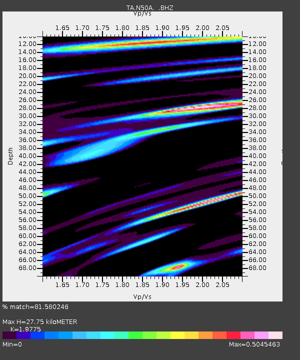
| Estimated Moho Depth: |
27.75 km |
| Estimated Crust Vp/Vs: |
1.98 |
| Assumed Crust Vp: |
6.498 km/s |
| Estimated Crust Vs: |
3.286 km/s |
| Estimated Crust Poisson's Ratio: |
0.33 |
|
| Radial Match: |
81.580246 % |
| Radial Bump: |
375 |
| Transverse Match: |
60.070644 % |
| Transverse Bump: |
400 |
| SOD ConfigId: |
469095 |
| Insert Time: |
2013-02-22 05:31:39.529 +0000 |
| GWidth: |
2.5 |
| Max Bumps: |
400 |
| Tol: |
0.001 |
|
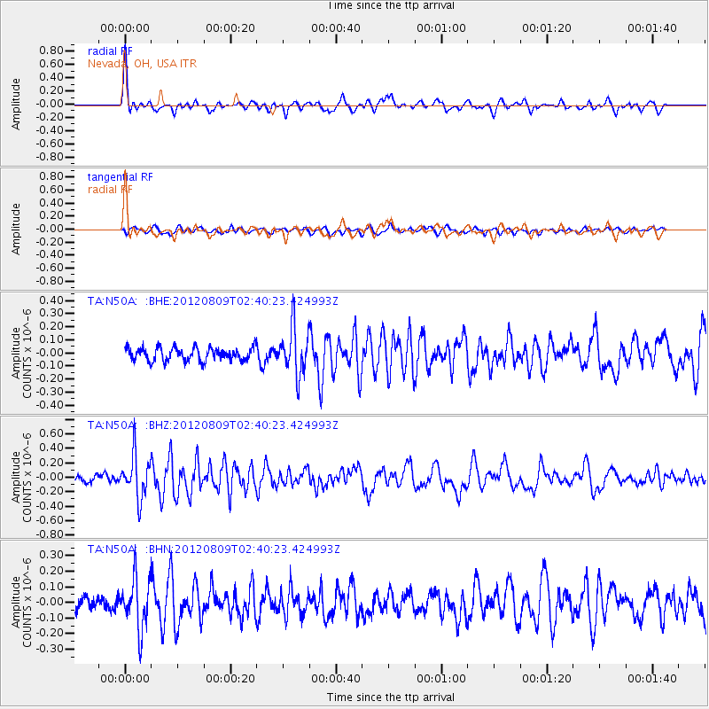
Signal To Noise
| Channel | StoN | STA | LTA |
| TA:N50A: :BHZ:20120809T02:40:23.424993Z | 4.8657928 | 2.9398478E-7 | 6.0418685E-8 |
| TA:N50A: :BHN:20120809T02:40:23.424993Z | 3.818936 | 1.5793951E-7 | 4.1356937E-8 |
| TA:N50A: :BHE:20120809T02:40:23.424993Z | 3.5613985 | 1.7860991E-7 | 5.015162E-8 |
| Arrivals |
| Ps | 4.5 SECOND |
| PpPs | 12 SECOND |
| PsPs/PpSs | 16 SECOND |


