You are here: Home > Network List > TA - USArray Transportable Network (new EarthScope stations) Stations List
> Station M49A Liberty Center, OH, USA > Earthquake Result Viewer
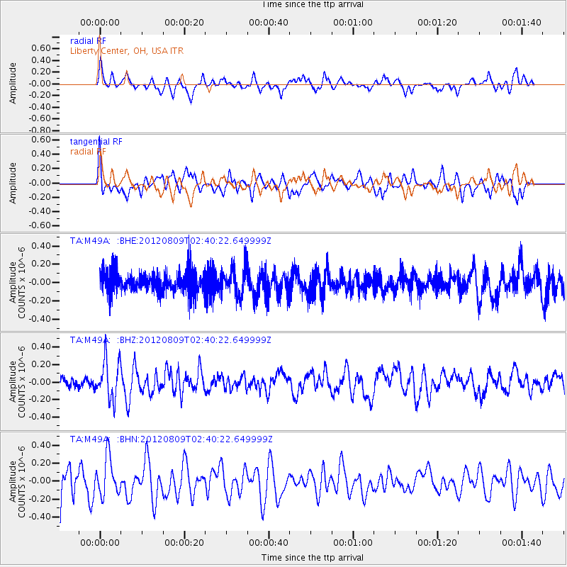
M49A Liberty Center, OH, USA - Earthquake Result Viewer
*The percent match for this event was below the threshold and hence no stack was calculated.
| Earthquake location: |
Revilla Gigedo Islands Region |
| Earthquake latitude/longitude: |
19.9/-109.3 |
| Earthquake time(UTC): |
2012/08/09 (222) 02:34:41 GMT |
| Earthquake Depth: |
10 km |
| Earthquake Magnitude: |
5.6 MW, 5.0 MS, 5.1 MB, 5.5 MW |
| Earthquake Catalog/Contributor: |
WHDF/NEIC |
|
| Network: |
TA USArray Transportable Network (new EarthScope stations) |
| Station: |
M49A Liberty Center, OH, USA |
| Lat/Lon: |
41.47 N/83.98 W |
| Elevation: |
203 m |
|
| Distance: |
30.4 deg |
| Az: |
39.498 deg |
| Baz: |
232.776 deg |
| Ray Param: |
$rayparam |
*The percent match for this event was below the threshold and hence was not used in the summary stack. |
|
| Radial Match: |
47.539265 % |
| Radial Bump: |
386 |
| Transverse Match: |
44.60509 % |
| Transverse Bump: |
400 |
| SOD ConfigId: |
469095 |
| Insert Time: |
2013-02-22 05:31:48.486 +0000 |
| GWidth: |
2.5 |
| Max Bumps: |
400 |
| Tol: |
0.001 |
|
Signal To Noise
| Channel | StoN | STA | LTA |
| TA:M49A: :BHZ:20120809T02:40:22.649999Z | 3.5794582 | 2.2663946E-7 | 6.33167E-8 |
| TA:M49A: :BHN:20120809T02:40:22.649999Z | 0.8339102 | 2.1804428E-7 | 2.6147214E-7 |
| TA:M49A: :BHE:20120809T02:40:22.649999Z | 1.3296264 | 1.5668542E-7 | 1.1784169E-7 |
| Arrivals |
| Ps | |
| PpPs | |
| PsPs/PpSs | |


