You are here: Home > Network List > G - GEOSCOPE Stations List
> Station TAM Tamanrasset, Algeria > Earthquake Result Viewer
TAM Tamanrasset, Algeria - Earthquake Result Viewer
| Earthquake location: |
Hindu Kush Region, Afghanistan |
| Earthquake latitude/longitude: |
36.5/70.5 |
| Earthquake time(UTC): |
2002/03/03 (062) 12:08:19 GMT |
| Earthquake Depth: |
226 km |
| Earthquake Magnitude: |
6.6 MB, 7.4 MW, 7.3 MW |
| Earthquake Catalog/Contributor: |
WHDF/NEIC |
|
| Network: |
G GEOSCOPE |
| Station: |
TAM Tamanrasset, Algeria |
| Lat/Lon: |
22.79 N/5.53 E |
| Elevation: |
1377 m |
|
| Distance: |
57.1 deg |
| Az: |
275.395 deg |
| Baz: |
60.37 deg |
| Ray Param: |
0.062942006 |
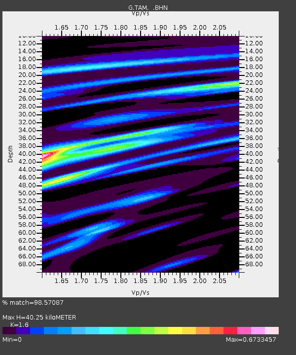
| Estimated Moho Depth: |
40.25 km |
| Estimated Crust Vp/Vs: |
1.60 |
| Assumed Crust Vp: |
6.61 km/s |
| Estimated Crust Vs: |
4.131 km/s |
| Estimated Crust Poisson's Ratio: |
0.18 |
|
| Radial Match: |
98.57087 % |
| Radial Bump: |
260 |
| Transverse Match: |
94.03587 % |
| Transverse Bump: |
400 |
| SOD ConfigId: |
20082 |
| Insert Time: |
2010-02-27 00:33:41.365 +0000 |
| GWidth: |
2.5 |
| Max Bumps: |
400 |
| Tol: |
0.001 |
|

Signal To Noise
| Channel | StoN | STA | LTA |
| G:TAM: :BHN:20020303T12:17:11.88801Z | 15.448725 | 2.1534943E-6 | 1.3939625E-7 |
| G:TAM: :BHE:20020303T12:17:11.88801Z | 12.746202 | 3.8097342E-6 | 2.988917E-7 |
| G:TAM: :BHZ:20020303T12:17:11.88801Z | 14.992059 | 9.135445E-6 | 6.0935224E-7 |
| Arrivals |
| Ps | 3.9 SECOND |
| PpPs | 15 SECOND |
| PsPs/PpSs | 19 SECOND |


