You are here: Home > Network List > CI - Caltech Regional Seismic Network Stations List
> Station CWC Cottonwood Creek, Lone Pine, CA, USA > Earthquake Result Viewer
CWC Cottonwood Creek, Lone Pine, CA, USA - Earthquake Result Viewer
| Earthquake location: |
Fox Islands, Aleutian Islands |
| Earthquake latitude/longitude: |
52.6/-167.4 |
| Earthquake time(UTC): |
2012/08/10 (223) 18:37:43 GMT |
| Earthquake Depth: |
13 km |
| Earthquake Magnitude: |
5.9 MB, 6.2 MS, 6.2 MW, 6.2 MW |
| Earthquake Catalog/Contributor: |
WHDF/NEIC |
|
| Network: |
CI Caltech Regional Seismic Network |
| Station: |
CWC Cottonwood Creek, Lone Pine, CA, USA |
| Lat/Lon: |
36.44 N/118.08 W |
| Elevation: |
1595 m |
|
| Distance: |
37.9 deg |
| Az: |
95.238 deg |
| Baz: |
311.177 deg |
| Ray Param: |
0.07586546 |
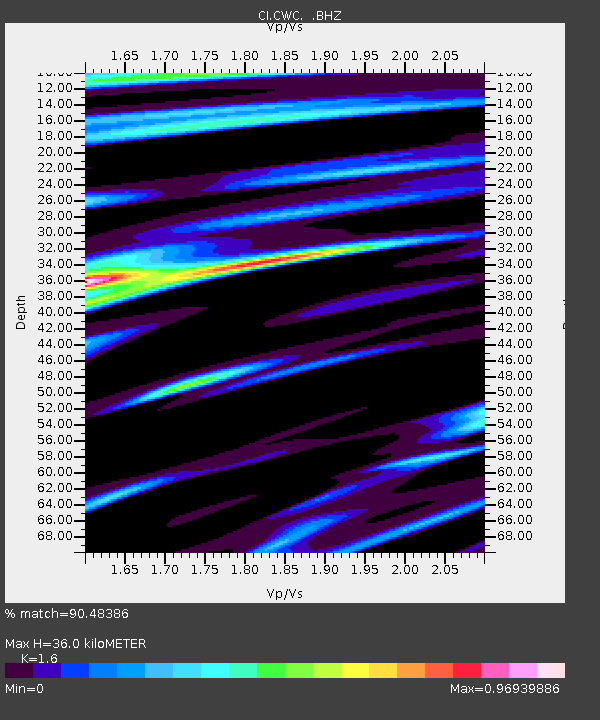
| Estimated Moho Depth: |
36.0 km |
| Estimated Crust Vp/Vs: |
1.60 |
| Assumed Crust Vp: |
6.291 km/s |
| Estimated Crust Vs: |
3.932 km/s |
| Estimated Crust Poisson's Ratio: |
0.18 |
|
| Radial Match: |
90.48386 % |
| Radial Bump: |
400 |
| Transverse Match: |
75.114685 % |
| Transverse Bump: |
400 |
| SOD ConfigId: |
469095 |
| Insert Time: |
2013-02-22 05:36:16.966 +0000 |
| GWidth: |
2.5 |
| Max Bumps: |
400 |
| Tol: |
0.001 |
|
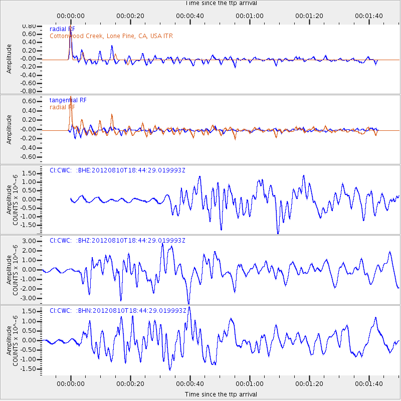
Signal To Noise
| Channel | StoN | STA | LTA |
| CI:CWC: :BHZ:20120810T18:44:29.019993Z | 2.7653303 | 4.775426E-7 | 1.7268917E-7 |
| CI:CWC: :BHN:20120810T18:44:29.019993Z | 2.2074149 | 2.0111102E-7 | 9.110703E-8 |
| CI:CWC: :BHE:20120810T18:44:29.019993Z | 3.4487274 | 3.4213247E-7 | 9.920543E-8 |
| Arrivals |
| Ps | 3.7 SECOND |
| PpPs | 14 SECOND |
| PsPs/PpSs | 17 SECOND |


