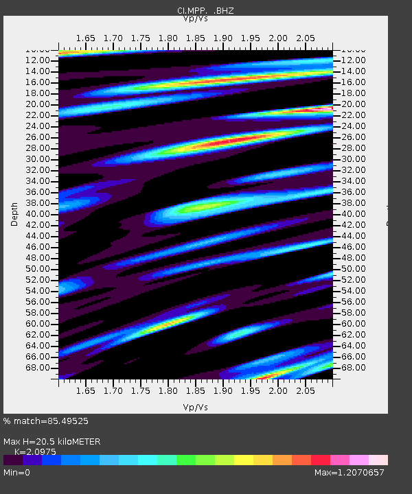
MPP McPhearson Peak - Earthquake Result Viewer
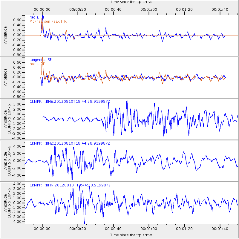
Earthquake location: Fox Islands, Aleutian Islands
Earthquake latitude/longitude: 52.6/-167.4
Earthquake time(UTC): 2012/08/10 (223) 18:37:43 GMT
Earthquake Depth: 13 km
Earthquake Magnitude: 5.9 MB, 6.2 MS, 6.2 MW, 6.2 MW
Earthquake Catalog/Contributor: WHDF/NEIC
Network: CI Caltech Regional Seismic Network
Station: MPP McPhearson Peak
Lat/Lon: 34.89 N/119.81 W
Elevation: 1739 m
Distance: 37.9 deg
Az: 98.649 deg
Baz: 312.863 deg
Ray Param: 0.07587275
Estimated Moho Depth: 20.5 km
Estimated Crust Vp/Vs: 2.10
Assumed Crust Vp: 6.1 km/s
Estimated Crust Vs: 2.908 km/s
Estimated Crust Poisson's Ratio: 0.35
Radial Match: 85.49525 %
Radial Bump: 400
Transverse Match: 80.706856 %
Transverse Bump: 400
SOD ConfigId: 469095
Insert Time: 2013-02-22 05:38:19.097 +0000
GWidth: 2.5
Max Bumps: 400
Tol: 0.001

Signal To Noise

ChannelStoNSTALTA
CI:MPP: :BHZ:20120810T18:44:28.919987Z2.71946078.369994E-73.0778136E-7
CI:MPP: :BHN:20120810T18:44:28.919987Z0.53311192.6098982E-74.8955917E-7
CI:MPP: :BHE:20120810T18:44:28.919987Z1.56202484.2884966E-72.7454726E-7
Arrivals
Ps3.9 SECOND
PpPs9.9 SECOND
PsPs/PpSs14 SECOND