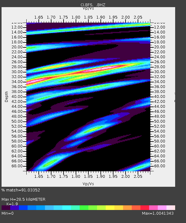
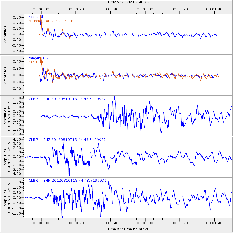
BFS Mt Baldy Forest Station - Earthquake Result Viewer

Earthquake location: Fox Islands, Aleutian Islands
Earthquake latitude/longitude: 52.6/-167.4
Earthquake time(UTC): 2012/08/10 (223) 18:37:43 GMT
Earthquake Depth: 13 km
Earthquake Magnitude: 5.9 MB, 6.2 MS, 6.2 MW, 6.2 MW
Earthquake Catalog/Contributor: WHDF/NEIC
Network: CI Caltech Regional Seismic Network
Station: BFS Mt Baldy Forest Station
Lat/Lon: 34.24 N/117.66 W
Elevation: 1312 m
Distance: 39.6 deg
Az: 97.468 deg
Baz: 313.159 deg
Ray Param: 0.07486577
Estimated Moho Depth: 28.5 km
Estimated Crust Vp/Vs: 1.90
Assumed Crust Vp: 6.276 km/s
Estimated Crust Vs: 3.303 km/s
Estimated Crust Poisson's Ratio: 0.31
Radial Match: 91.03352 %
Radial Bump: 400
Transverse Match: 79.02441 %
Transverse Bump: 400
SOD ConfigId: 469095
Insert Time: 2013-02-22 05:38:44.252 +0000
GWidth: 2.5
Max Bumps: 400
Tol: 0.001

Signal To Noise

ChannelStoNSTALTA
CI:BFS: :BHZ:20120810T18:44:43.519993Z4.128226.2793174E-71.5210713E-7
CI:BFS: :BHN:20120810T18:44:43.519993Z1.26776861.6105166E-71.2703553E-7
CI:BFS: :BHE:20120810T18:44:43.519993Z3.22855522.4761465E-77.6695194E-8
Arrivals
Ps4.4 SECOND
PpPs12 SECOND
PsPs/PpSs17 SECOND