You are here: Home > Network List > CI - Caltech Regional Seismic Network Stations List
> Station SCZ2 SCZ2, Santa Cruz Is. (E end), CA, USA > Earthquake Result Viewer
SCZ2 SCZ2, Santa Cruz Is. (E end), CA, USA - Earthquake Result Viewer
| Earthquake location: |
Fox Islands, Aleutian Islands |
| Earthquake latitude/longitude: |
52.6/-167.4 |
| Earthquake time(UTC): |
2012/08/10 (223) 18:37:43 GMT |
| Earthquake Depth: |
13 km |
| Earthquake Magnitude: |
5.9 MB, 6.2 MS, 6.2 MW, 6.2 MW |
| Earthquake Catalog/Contributor: |
WHDF/NEIC |
|
| Network: |
CI Caltech Regional Seismic Network |
| Station: |
SCZ2 SCZ2, Santa Cruz Is. (E end), CA, USA |
| Lat/Lon: |
34.00 N/119.64 W |
| Elevation: |
440 m |
|
| Distance: |
38.6 deg |
| Az: |
99.534 deg |
| Baz: |
313.658 deg |
| Ray Param: |
0.07545752 |
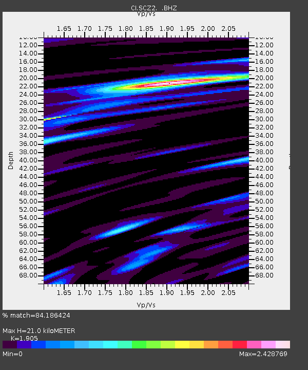
| Estimated Moho Depth: |
21.0 km |
| Estimated Crust Vp/Vs: |
1.90 |
| Assumed Crust Vp: |
6.048 km/s |
| Estimated Crust Vs: |
3.175 km/s |
| Estimated Crust Poisson's Ratio: |
0.31 |
|
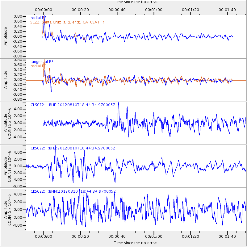
| Radial Match: |
84.186424 % |
| Radial Bump: |
400 |
| Transverse Match: |
76.29301 % |
| Transverse Bump: |
400 |
| SOD ConfigId: |
469095 |
| Insert Time: |
2013-02-22 05:39:00.252 +0000 |
| GWidth: |
2.5 |
| Max Bumps: |
400 |
| Tol: |
0.001 |
|
Signal To Noise
| Channel | StoN | STA | LTA |
| CI:SCZ2: :BHZ:20120810T18:44:34.970005Z | 2.4134357 | 1.2364936E-6 | 5.1233746E-7 |
| CI:SCZ2: :BHN:20120810T18:44:34.970005Z | 1.5718504 | 1.09501E-6 | 6.966376E-7 |
| CI:SCZ2: :BHE:20120810T18:44:34.970005Z | 1.6208593 | 7.706617E-7 | 4.754649E-7 |
| Arrivals |
| Ps | 3.3 SECOND |
| PpPs | 9.5 SECOND |
| PsPs/PpSs | 13 SECOND |


