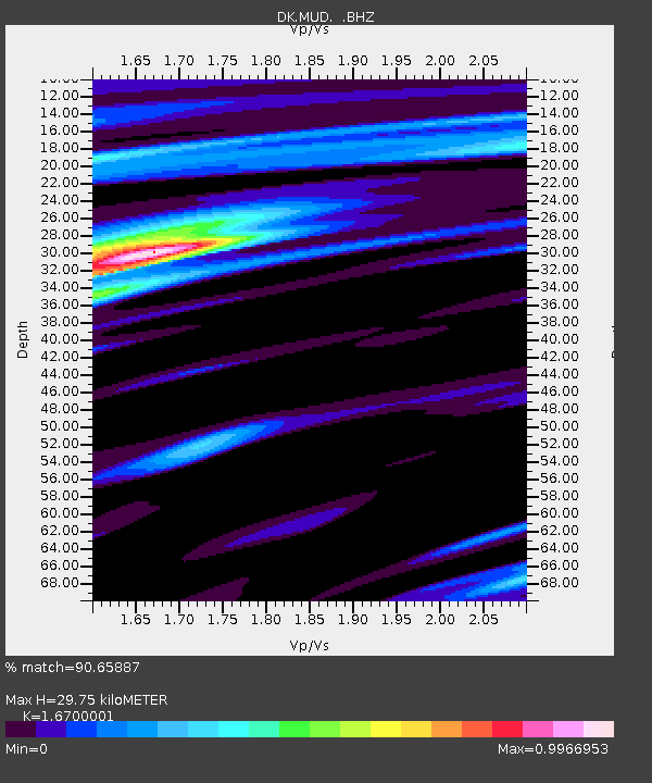
MUD MONSTED U'GRND, DENMARK - Earthquake Result Viewer

Earthquake location: Fox Islands, Aleutian Islands
Earthquake latitude/longitude: 52.6/-167.4
Earthquake time(UTC): 2012/08/10 (223) 18:37:43 GMT
Earthquake Depth: 13 km
Earthquake Magnitude: 5.9 MB, 6.2 MS, 6.2 MW, 6.2 MW
Earthquake Catalog/Contributor: WHDF/NEIC
Network: DK Danish Seismological Network
Station: MUD MONSTED U'GRND, DENMARK
Lat/Lon: 56.46 N/9.17 E
Elevation: 12 m
Distance: 71.2 deg
Az: 1.996 deg
Baz: 357.809 deg
Ray Param: 0.05445261
Estimated Moho Depth: 29.75 km
Estimated Crust Vp/Vs: 1.67
Assumed Crust Vp: 6.159 km/s
Estimated Crust Vs: 3.688 km/s
Estimated Crust Poisson's Ratio: 0.22
Radial Match: 90.65887 %
Radial Bump: 400
Transverse Match: 60.04333 %
Transverse Bump: 400
SOD ConfigId: 469095
Insert Time: 2013-02-22 05:39:51.761 +0000
GWidth: 2.5
Max Bumps: 400
Tol: 0.001

Signal To Noise

ChannelStoNSTALTA
DK:MUD: :BHZ:20120810T18:48:30.592991Z4.69794037.809469E-71.6623176E-7
DK:MUD: :BHN:20120810T18:48:30.572971Z1.8299382.8163424E-71.539037E-7
DK:MUD: :BHE:20120810T18:48:30.572971Z0.94278081.315935E-71.3958017E-7
Arrivals
Ps3.4 SECOND
PpPs12 SECOND
PsPs/PpSs16 SECOND