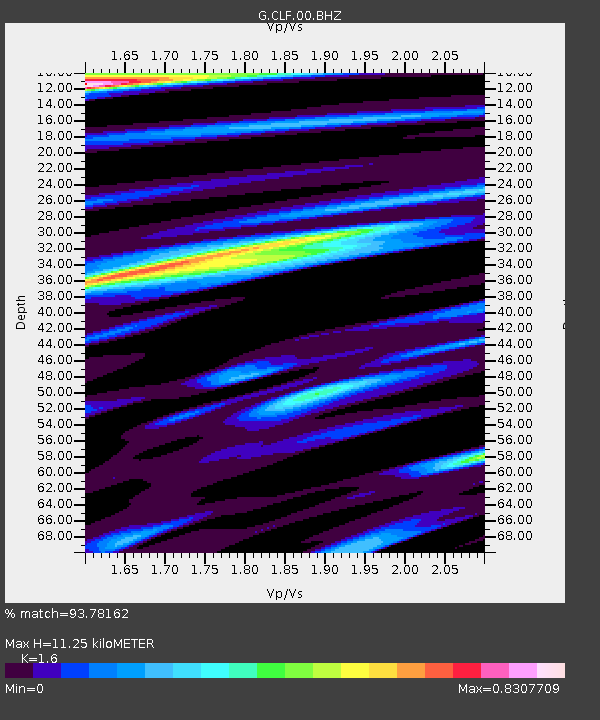
CLF Chambon la Foret observatory, France - Earthquake Result Viewer
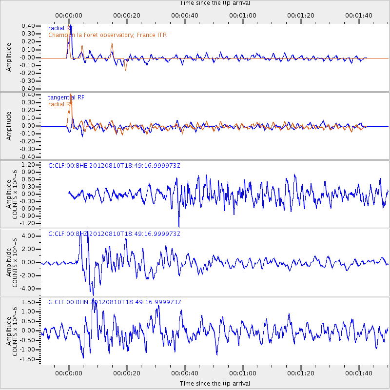
Earthquake location: Fox Islands, Aleutian Islands
Earthquake latitude/longitude: 52.6/-167.4
Earthquake time(UTC): 2012/08/10 (223) 18:37:43 GMT
Earthquake Depth: 13 km
Earthquake Magnitude: 5.9 MB, 6.2 MS, 6.2 MW, 6.2 MW
Earthquake Catalog/Contributor: WHDF/NEIC
Network: G GEOSCOPE
Station: CLF Chambon la Foret observatory, France
Lat/Lon: 48.03 N/2.26 E
Elevation: 145 m
Distance: 79.3 deg
Az: 7.028 deg
Baz: 353.621 deg
Ray Param: 0.0490274
Estimated Moho Depth: 11.25 km
Estimated Crust Vp/Vs: 1.60
Assumed Crust Vp: 6.12 km/s
Estimated Crust Vs: 3.825 km/s
Estimated Crust Poisson's Ratio: 0.18
Radial Match: 93.78162 %
Radial Bump: 400
Transverse Match: 76.13711 %
Transverse Bump: 400
SOD ConfigId: 469095
Insert Time: 2013-02-22 05:40:16.436 +0000
GWidth: 2.5
Max Bumps: 400
Tol: 0.001

Signal To Noise

ChannelStoNSTALTA
G:CLF:00:BHZ:20120810T18:49:16.999973Z12.0907111.5149525E-61.2529888E-7
G:CLF:00:BHN:20120810T18:49:16.999973Z4.00220634.3493725E-71.08674364E-7
G:CLF:00:BHE:20120810T18:49:16.999973Z1.58273152.0410745E-71.2895899E-7
Arrivals
Ps1.1 SECOND
PpPs4.6 SECOND
PsPs/PpSs5.8 SECOND