You are here: Home > Network List > G - GEOSCOPE Stations List
> Station TAM Tamanrasset, Algeria > Earthquake Result Viewer
TAM Tamanrasset, Algeria - Earthquake Result Viewer
| Earthquake location: |
South Indian Ocean |
| Earthquake latitude/longitude: |
-36.7/53.4 |
| Earthquake time(UTC): |
2004/01/11 (011) 04:32:47 GMT |
| Earthquake Depth: |
5.3 km |
| Earthquake Magnitude: |
6.1 MB, 6.1 MS, 6.2 MW, 6.2 MW |
| Earthquake Catalog/Contributor: |
WHDF/NEIC |
|
| Network: |
G GEOSCOPE |
| Station: |
TAM Tamanrasset, Algeria |
| Lat/Lon: |
22.79 N/5.53 E |
| Elevation: |
1377 m |
|
| Distance: |
74.4 deg |
| Az: |
314.76 deg |
| Baz: |
141.8 deg |
| Ray Param: |
0.052364323 |
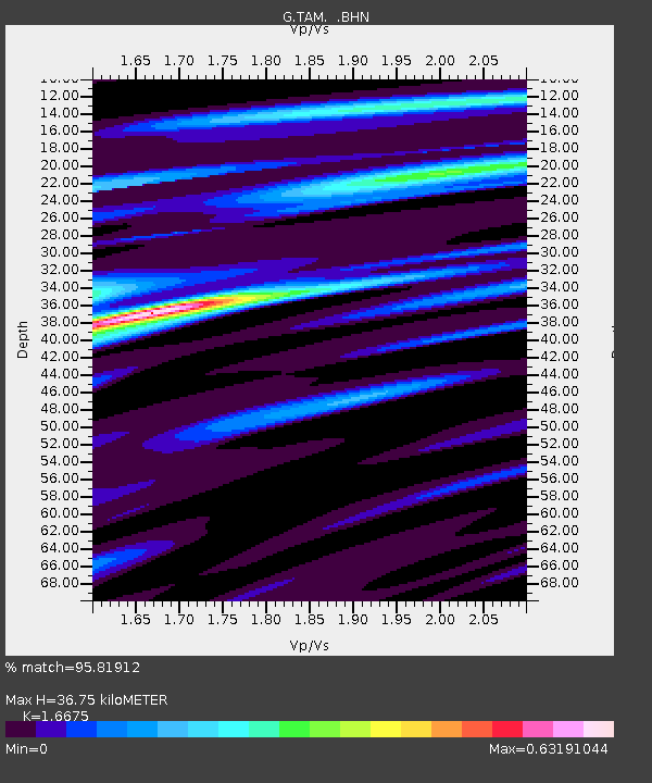
| Estimated Moho Depth: |
36.75 km |
| Estimated Crust Vp/Vs: |
1.67 |
| Assumed Crust Vp: |
6.61 km/s |
| Estimated Crust Vs: |
3.964 km/s |
| Estimated Crust Poisson's Ratio: |
0.22 |
|
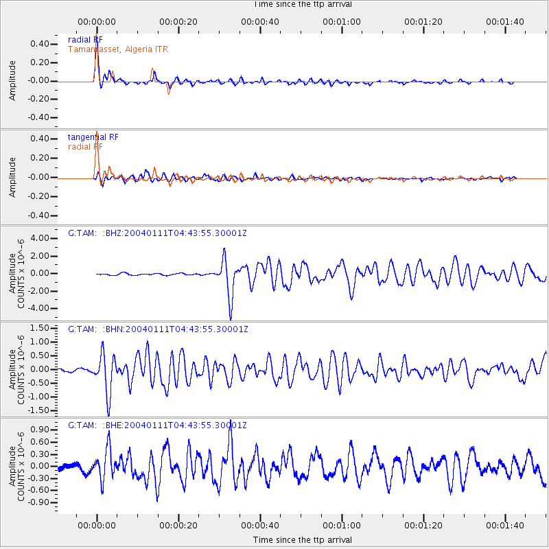
| Radial Match: |
95.81912 % |
| Radial Bump: |
347 |
| Transverse Match: |
80.24055 % |
| Transverse Bump: |
400 |
| SOD ConfigId: |
2459 |
| Insert Time: |
2010-02-27 00:34:14.674 +0000 |
| GWidth: |
2.5 |
| Max Bumps: |
400 |
| Tol: |
0.001 |
|
Signal To Noise
| Channel | StoN | STA | LTA |
| G:TAM: :BHN:20040111T04:43:55.30001Z | 13.543875 | 7.215692E-7 | 5.3276423E-8 |
| G:TAM: :BHE:20040111T04:43:55.30001Z | 4.01339 | 3.8387097E-7 | 9.564755E-8 |
| G:TAM: :BHZ:20040111T04:43:55.30001Z | 21.041937 | 2.1190772E-6 | 1.00707325E-7 |
| Arrivals |
| Ps | 3.9 SECOND |
| PpPs | 14 SECOND |
| PsPs/PpSs | 18 SECOND |


