You are here: Home > Network List > G - GEOSCOPE Stations List
> Station TAM Tamanrasset, Algeria > Earthquake Result Viewer
TAM Tamanrasset, Algeria - Earthquake Result Viewer
| Earthquake location: |
Pakistan |
| Earthquake latitude/longitude: |
34.7/73.1 |
| Earthquake time(UTC): |
2005/10/08 (281) 10:46:28 GMT |
| Earthquake Depth: |
8.0 km |
| Earthquake Magnitude: |
6.0 MB, 6.3 MS, 6.4 MW, 6.2 MW |
| Earthquake Catalog/Contributor: |
WHDF/NEIC |
|
| Network: |
G GEOSCOPE |
| Station: |
TAM Tamanrasset, Algeria |
| Lat/Lon: |
22.79 N/5.53 E |
| Elevation: |
1377 m |
|
| Distance: |
59.4 deg |
| Az: |
277.845 deg |
| Baz: |
62.141 deg |
| Ray Param: |
0.06219082 |
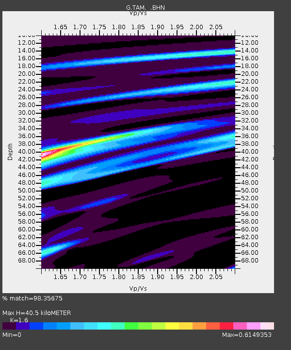
| Estimated Moho Depth: |
40.5 km |
| Estimated Crust Vp/Vs: |
1.60 |
| Assumed Crust Vp: |
6.61 km/s |
| Estimated Crust Vs: |
4.131 km/s |
| Estimated Crust Poisson's Ratio: |
0.18 |
|
| Radial Match: |
98.35675 % |
| Radial Bump: |
220 |
| Transverse Match: |
92.41084 % |
| Transverse Bump: |
400 |
| SOD ConfigId: |
2564 |
| Insert Time: |
2010-02-27 00:34:22.358 +0000 |
| GWidth: |
2.5 |
| Max Bumps: |
400 |
| Tol: |
0.001 |
|
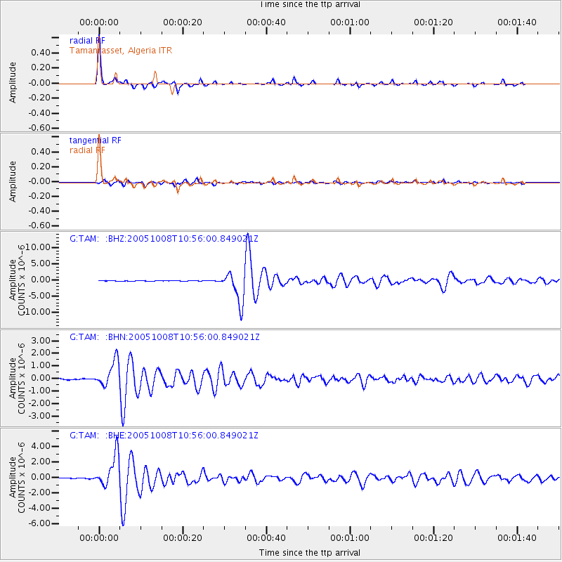
Signal To Noise
| Channel | StoN | STA | LTA |
| G:TAM: :BHN:20051008T10:56:00.849021Z | 20.980404 | 1.0477081E-6 | 4.9937462E-8 |
| G:TAM: :BHE:20051008T10:56:00.849021Z | 48.630974 | 2.1412652E-6 | 4.4030894E-8 |
| G:TAM: :BHZ:20051008T10:56:00.849021Z | 87.81238 | 4.8901256E-6 | 5.5688346E-8 |
| Arrivals |
| Ps | 3.9 SECOND |
| PpPs | 15 SECOND |
| PsPs/PpSs | 19 SECOND |


