You are here: Home > Network List > TA - USArray Transportable Network (new EarthScope stations) Stations List
> Station R11A Troy Canyon, Currant, NV, USA > Earthquake Result Viewer
R11A Troy Canyon, Currant, NV, USA - Earthquake Result Viewer
| Earthquake location: |
Fox Islands, Aleutian Islands |
| Earthquake latitude/longitude: |
52.6/-167.4 |
| Earthquake time(UTC): |
2012/08/10 (223) 18:37:43 GMT |
| Earthquake Depth: |
13 km |
| Earthquake Magnitude: |
5.9 MB, 6.2 MS, 6.2 MW, 6.2 MW |
| Earthquake Catalog/Contributor: |
WHDF/NEIC |
|
| Network: |
TA USArray Transportable Network (new EarthScope stations) |
| Station: |
R11A Troy Canyon, Currant, NV, USA |
| Lat/Lon: |
38.35 N/115.59 W |
| Elevation: |
1756 m |
|
| Distance: |
38.2 deg |
| Az: |
90.795 deg |
| Baz: |
309.186 deg |
| Ray Param: |
0.075698085 |
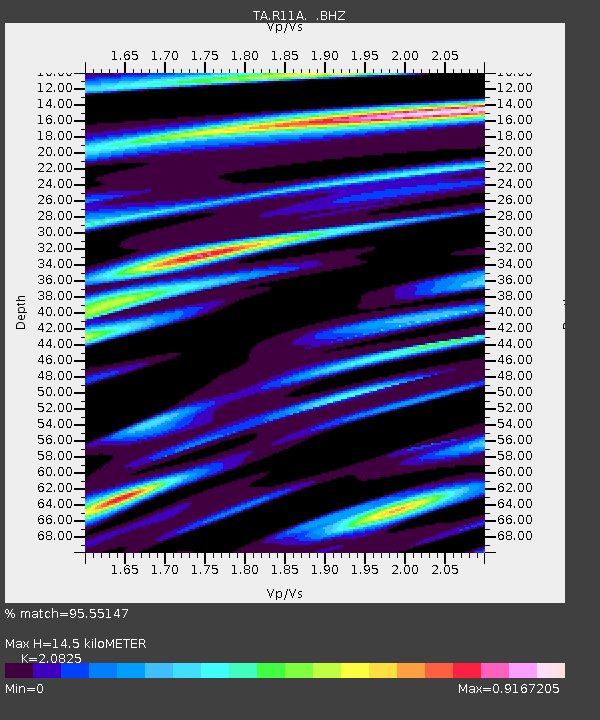
| Estimated Moho Depth: |
14.5 km |
| Estimated Crust Vp/Vs: |
2.08 |
| Assumed Crust Vp: |
6.276 km/s |
| Estimated Crust Vs: |
3.014 km/s |
| Estimated Crust Poisson's Ratio: |
0.35 |
|
| Radial Match: |
95.55147 % |
| Radial Bump: |
385 |
| Transverse Match: |
83.53021 % |
| Transverse Bump: |
400 |
| SOD ConfigId: |
469095 |
| Insert Time: |
2013-02-22 05:48:52.573 +0000 |
| GWidth: |
2.5 |
| Max Bumps: |
400 |
| Tol: |
0.001 |
|

Signal To Noise
| Channel | StoN | STA | LTA |
| TA:R11A: :BHZ:20120810T18:44:31.47501Z | 3.6633794 | 2.9036667E-7 | 7.926197E-8 |
| TA:R11A: :BHN:20120810T18:44:31.47501Z | 3.8671484 | 1.5745508E-7 | 4.0716067E-8 |
| TA:R11A: :BHE:20120810T18:44:31.47501Z | 2.8316061 | 1.6825707E-7 | 5.942107E-8 |
| Arrivals |
| Ps | 2.7 SECOND |
| PpPs | 6.7 SECOND |
| PsPs/PpSs | 9.4 SECOND |


