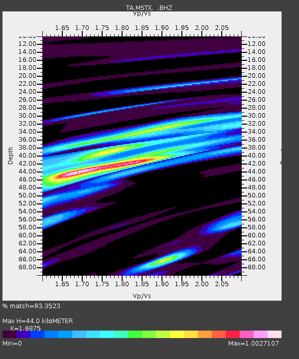
MSTX Muleshoe, TX, USA - Earthquake Result Viewer

Earthquake location: Fox Islands, Aleutian Islands
Earthquake latitude/longitude: 52.6/-167.4
Earthquake time(UTC): 2012/08/10 (223) 18:37:43 GMT
Earthquake Depth: 13 km
Earthquake Magnitude: 5.9 MB, 6.2 MS, 6.2 MW, 6.2 MW
Earthquake Catalog/Contributor: WHDF/NEIC
Network: TA USArray Transportable Network (new EarthScope stations)
Station: MSTX Muleshoe, TX, USA
Lat/Lon: 33.97 N/102.77 W
Elevation: 1167 m
Distance: 48.9 deg
Az: 85.669 deg
Baz: 313.005 deg
Ray Param: 0.06906739
Estimated Moho Depth: 44.0 km
Estimated Crust Vp/Vs: 1.69
Assumed Crust Vp: 6.129 km/s
Estimated Crust Vs: 3.632 km/s
Estimated Crust Poisson's Ratio: 0.23
Radial Match: 93.3523 %
Radial Bump: 394
Transverse Match: 76.15906 %
Transverse Bump: 400
SOD ConfigId: 469095
Insert Time: 2013-02-22 05:49:14.715 +0000
GWidth: 2.5
Max Bumps: 400
Tol: 0.001

Signal To Noise

ChannelStoNSTALTA
TA:MSTX: :BHZ:20120810T18:45:57.35001Z5.7254335.082609E-78.877249E-8
TA:MSTX: :BHN:20120810T18:45:57.35001Z1.91201581.549865E-78.1059206E-8
TA:MSTX: :BHE:20120810T18:45:57.35001Z1.60500961.4371349E-78.9540585E-8
Arrivals
Ps5.2 SECOND
PpPs18 SECOND
PsPs/PpSs23 SECOND