You are here: Home > Network List > TA - USArray Transportable Network (new EarthScope stations) Stations List
> Station H36A Jessenland, Henderson, MN, USA > Earthquake Result Viewer
H36A Jessenland, Henderson, MN, USA - Earthquake Result Viewer
| Earthquake location: |
Fox Islands, Aleutian Islands |
| Earthquake latitude/longitude: |
52.6/-167.4 |
| Earthquake time(UTC): |
2012/08/10 (223) 18:37:43 GMT |
| Earthquake Depth: |
13 km |
| Earthquake Magnitude: |
5.9 MB, 6.2 MS, 6.2 MW, 6.2 MW |
| Earthquake Catalog/Contributor: |
WHDF/NEIC |
|
| Network: |
TA USArray Transportable Network (new EarthScope stations) |
| Station: |
H36A Jessenland, Henderson, MN, USA |
| Lat/Lon: |
44.58 N/93.93 W |
| Elevation: |
311 m |
|
| Distance: |
47.3 deg |
| Az: |
68.831 deg |
| Baz: |
307.317 deg |
| Ray Param: |
0.070081115 |
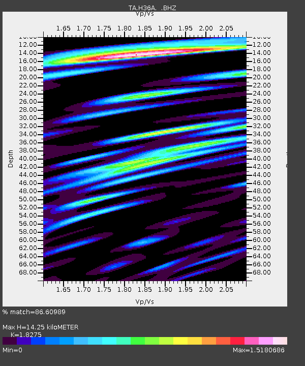
| Estimated Moho Depth: |
14.25 km |
| Estimated Crust Vp/Vs: |
1.83 |
| Assumed Crust Vp: |
6.571 km/s |
| Estimated Crust Vs: |
3.595 km/s |
| Estimated Crust Poisson's Ratio: |
0.29 |
|
| Radial Match: |
86.60989 % |
| Radial Bump: |
400 |
| Transverse Match: |
60.920986 % |
| Transverse Bump: |
400 |
| SOD ConfigId: |
469095 |
| Insert Time: |
2013-02-22 05:52:08.595 +0000 |
| GWidth: |
2.5 |
| Max Bumps: |
400 |
| Tol: |
0.001 |
|
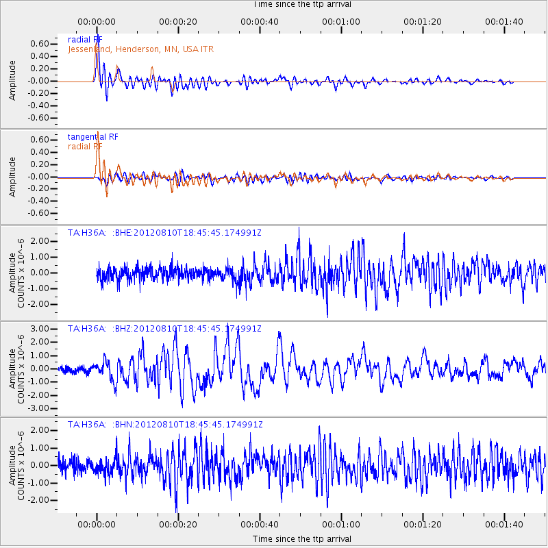
Signal To Noise
| Channel | StoN | STA | LTA |
| TA:H36A: :BHZ:20120810T18:45:45.174991Z | 4.2862196 | 7.5346753E-7 | 1.7578836E-7 |
| TA:H36A: :BHN:20120810T18:45:45.174991Z | 1.2537447 | 4.2434772E-7 | 3.384642E-7 |
| TA:H36A: :BHE:20120810T18:45:45.174991Z | 1.0438104 | 3.7735688E-7 | 3.6151863E-7 |
| Arrivals |
| Ps | 1.9 SECOND |
| PpPs | 5.8 SECOND |
| PsPs/PpSs | 7.7 SECOND |


