You are here: Home > Network List > TA - USArray Transportable Network (new EarthScope stations) Stations List
> Station W40A Ferguson Farm, Pottsville, AR, USA > Earthquake Result Viewer
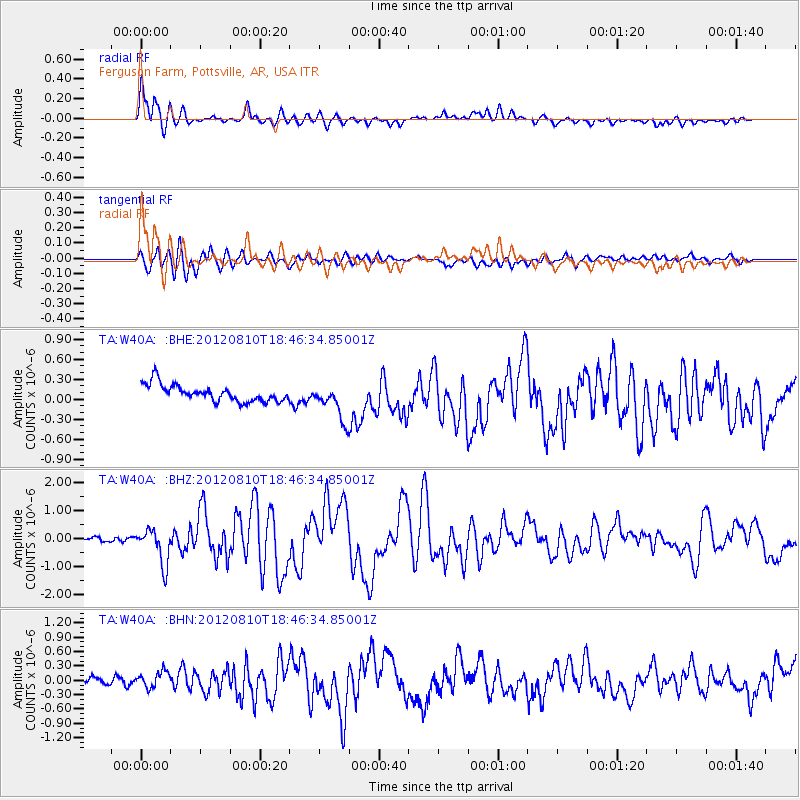
W40A Ferguson Farm, Pottsville, AR, USA - Earthquake Result Viewer
| Earthquake location: |
Fox Islands, Aleutian Islands |
| Earthquake latitude/longitude: |
52.6/-167.4 |
| Earthquake time(UTC): |
2012/08/10 (223) 18:37:43 GMT |
| Earthquake Depth: |
13 km |
| Earthquake Magnitude: |
5.9 MB, 6.2 MS, 6.2 MW, 6.2 MW |
| Earthquake Catalog/Contributor: |
WHDF/NEIC |
|
| Network: |
TA USArray Transportable Network (new EarthScope stations) |
| Station: |
W40A Ferguson Farm, Pottsville, AR, USA |
| Lat/Lon: |
35.19 N/93.07 W |
| Elevation: |
108 m |
|
| Distance: |
53.9 deg |
| Az: |
77.521 deg |
| Baz: |
313.4 deg |
| Ray Param: |
0.065797344 |
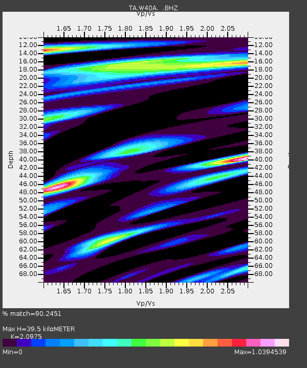
| Estimated Moho Depth: |
39.5 km |
| Estimated Crust Vp/Vs: |
2.10 |
| Assumed Crust Vp: |
6.498 km/s |
| Estimated Crust Vs: |
3.098 km/s |
| Estimated Crust Poisson's Ratio: |
0.35 |
|
| Radial Match: |
90.2451 % |
| Radial Bump: |
400 |
| Transverse Match: |
73.43879 % |
| Transverse Bump: |
400 |
| SOD ConfigId: |
469095 |
| Insert Time: |
2013-02-22 05:55:38.909 +0000 |
| GWidth: |
2.5 |
| Max Bumps: |
400 |
| Tol: |
0.001 |
|
Signal To Noise
| Channel | StoN | STA | LTA |
| TA:W40A: :BHZ:20120810T18:46:34.85001Z | 5.373132 | 6.357214E-7 | 1.1831486E-7 |
| TA:W40A: :BHN:20120810T18:46:34.85001Z | 1.7287277 | 1.7805867E-7 | 1.0299984E-7 |
| TA:W40A: :BHE:20120810T18:46:34.85001Z | 2.1545928 | 2.6871768E-7 | 1.2471854E-7 |
| Arrivals |
| Ps | 7.0 SECOND |
| PpPs | 18 SECOND |
| PsPs/PpSs | 25 SECOND |


