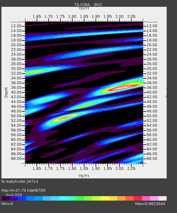
V39A Pettigrew, AR, USA - Earthquake Result Viewer

Earthquake location: Fox Islands, Aleutian Islands
Earthquake latitude/longitude: 52.6/-167.4
Earthquake time(UTC): 2012/08/10 (223) 18:37:43 GMT
Earthquake Depth: 13 km
Earthquake Magnitude: 5.9 MB, 6.2 MS, 6.2 MW, 6.2 MW
Earthquake Catalog/Contributor: WHDF/NEIC
Network: TA USArray Transportable Network (new EarthScope stations)
Station: V39A Pettigrew, AR, USA
Lat/Lon: 35.84 N/93.64 W
Elevation: 744 m
Distance: 53.1 deg
Az: 77.335 deg
Baz: 312.957 deg
Ray Param: 0.06632295
Estimated Moho Depth: 37.75 km
Estimated Crust Vp/Vs: 2.02
Assumed Crust Vp: 6.498 km/s
Estimated Crust Vs: 3.225 km/s
Estimated Crust Poisson's Ratio: 0.34
Radial Match: 94.34714 %
Radial Bump: 392
Transverse Match: 75.89004 %
Transverse Bump: 400
SOD ConfigId: 469095
Insert Time: 2013-02-22 05:56:02.687 +0000
GWidth: 2.5
Max Bumps: 400
Tol: 0.001

Signal To Noise

ChannelStoNSTALTA
TA:V39A: :BHZ:20120810T18:46:29.10001Z8.2826054.277392E-75.1643077E-8
TA:V39A: :BHN:20120810T18:46:29.10001Z2.68867831.6719096E-76.2183325E-8
TA:V39A: :BHE:20120810T18:46:29.10001Z3.48363691.8151546E-75.210516E-8
Arrivals
Ps6.2 SECOND
PpPs17 SECOND
PsPs/PpSs23 SECOND