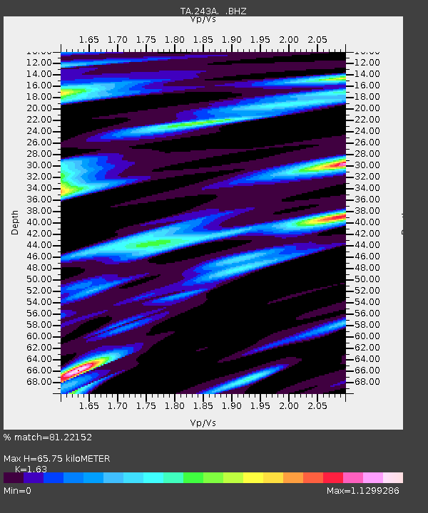
243A Waterproof, LA, USA - Earthquake Result Viewer
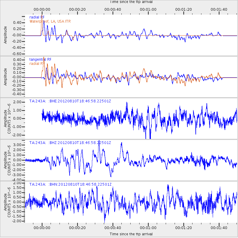
Earthquake location: Fox Islands, Aleutian Islands
Earthquake latitude/longitude: 52.6/-167.4
Earthquake time(UTC): 2012/08/10 (223) 18:37:43 GMT
Earthquake Depth: 13 km
Earthquake Magnitude: 5.9 MB, 6.2 MS, 6.2 MW, 6.2 MW
Earthquake Catalog/Contributor: WHDF/NEIC
Network: TA USArray Transportable Network (new EarthScope stations)
Station: 243A Waterproof, LA, USA
Lat/Lon: 31.88 N/91.48 W
Elevation: 2.0 m
Distance: 57.1 deg
Az: 79.264 deg
Baz: 315.26 deg
Ray Param: 0.06367779
Estimated Moho Depth: 65.75 km
Estimated Crust Vp/Vs: 1.63
Assumed Crust Vp: 6.065 km/s
Estimated Crust Vs: 3.721 km/s
Estimated Crust Poisson's Ratio: 0.20
Radial Match: 81.22152 %
Radial Bump: 400
Transverse Match: 58.967915 %
Transverse Bump: 400
SOD ConfigId: 469095
Insert Time: 2013-02-22 05:56:30.420 +0000
GWidth: 2.5
Max Bumps: 400
Tol: 0.001

Signal To Noise

ChannelStoNSTALTA
TA:243A: :BHZ:20120810T18:46:58.22501Z2.65323354.5851272E-71.7281279E-7
TA:243A: :BHN:20120810T18:46:58.22501Z1.23443294.1352772E-73.3499407E-7
TA:243A: :BHE:20120810T18:46:58.22501Z1.13932674.3204264E-73.7920873E-7
Arrivals
Ps7.2 SECOND
PpPs27 SECOND
PsPs/PpSs34 SECOND