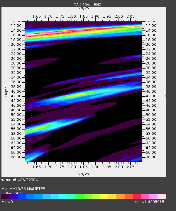
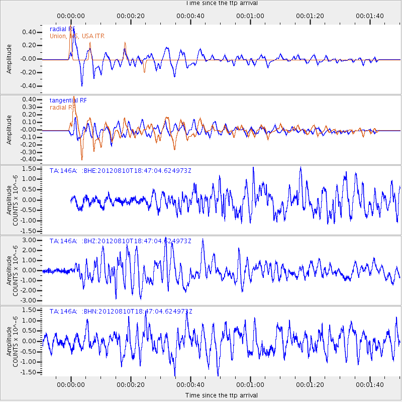
146A Union, MS, USA - Earthquake Result Viewer

Earthquake location: Fox Islands, Aleutian Islands
Earthquake latitude/longitude: 52.6/-167.4
Earthquake time(UTC): 2012/08/10 (223) 18:37:43 GMT
Earthquake Depth: 13 km
Earthquake Magnitude: 5.9 MB, 6.2 MS, 6.2 MW, 6.2 MW
Earthquake Catalog/Contributor: WHDF/NEIC
Network: TA USArray Transportable Network (new EarthScope stations)
Station: 146A Union, MS, USA
Lat/Lon: 32.64 N/89.06 W
Elevation: 164 m
Distance: 58.0 deg
Az: 76.906 deg
Baz: 315.285 deg
Ray Param: 0.06309361
Estimated Moho Depth: 15.75 km
Estimated Crust Vp/Vs: 1.61
Assumed Crust Vp: 6.201 km/s
Estimated Crust Vs: 3.864 km/s
Estimated Crust Poisson's Ratio: 0.18
Radial Match: 86.72884 %
Radial Bump: 400
Transverse Match: 77.41696 %
Transverse Bump: 400
SOD ConfigId: 469095
Insert Time: 2013-02-22 05:57:39.175 +0000
GWidth: 2.5
Max Bumps: 400
Tol: 0.001

Signal To Noise

ChannelStoNSTALTA
TA:146A: :BHZ:20120810T18:47:04.624973Z4.4302626.233071E-71.4069305E-7
TA:146A: :BHN:20120810T18:47:04.624973Z1.1608382.5591635E-72.2045829E-7
TA:146A: :BHE:20120810T18:47:04.624973Z1.61177292.7845306E-71.7276196E-7
Arrivals
Ps1.6 SECOND
PpPs6.3 SECOND
PsPs/PpSs7.9 SECOND