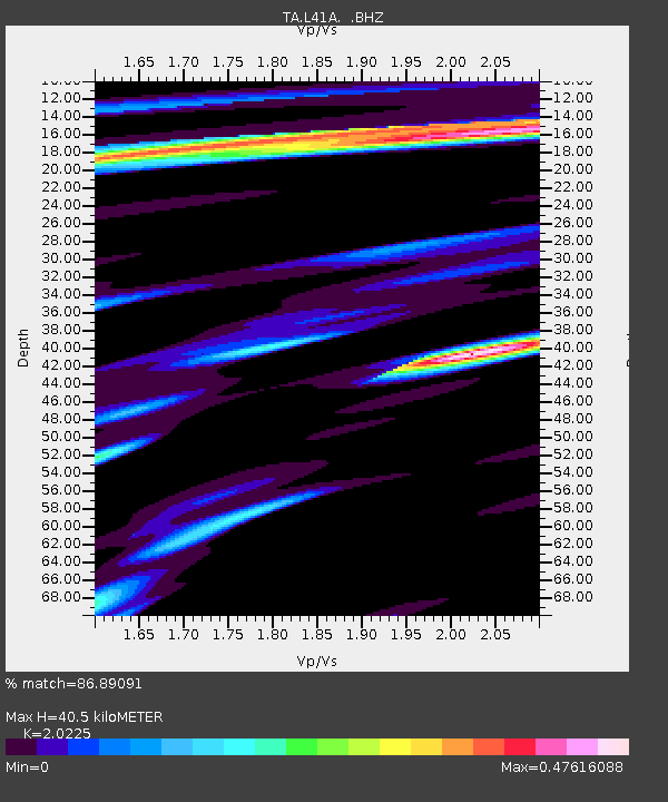
L41A Preston, IA, USA - Earthquake Result Viewer
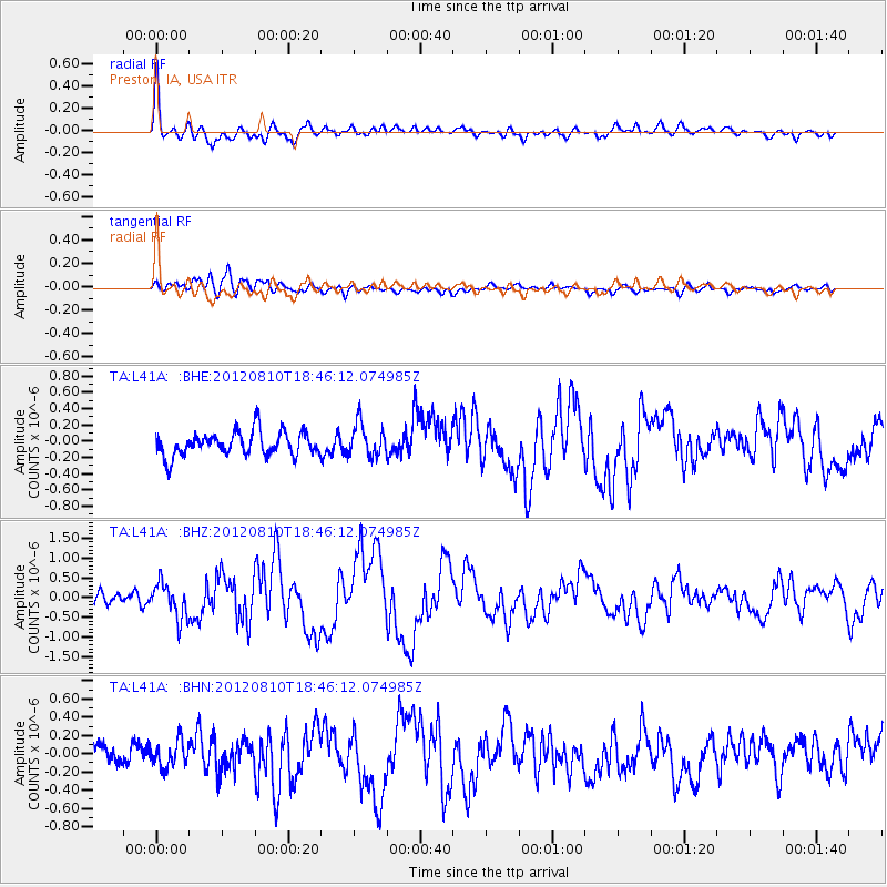
Earthquake location: Fox Islands, Aleutian Islands
Earthquake latitude/longitude: 52.6/-167.4
Earthquake time(UTC): 2012/08/10 (223) 18:37:43 GMT
Earthquake Depth: 13 km
Earthquake Magnitude: 5.9 MB, 6.2 MS, 6.2 MW, 6.2 MW
Earthquake Catalog/Contributor: WHDF/NEIC
Network: TA USArray Transportable Network (new EarthScope stations)
Station: L41A Preston, IA, USA
Lat/Lon: 42.08 N/90.50 W
Elevation: 238 m
Distance: 50.8 deg
Az: 69.346 deg
Baz: 310.0 deg
Ray Param: 0.067801684
Estimated Moho Depth: 40.5 km
Estimated Crust Vp/Vs: 2.02
Assumed Crust Vp: 6.53 km/s
Estimated Crust Vs: 3.229 km/s
Estimated Crust Poisson's Ratio: 0.34
Radial Match: 86.89091 %
Radial Bump: 400
Transverse Match: 55.283836 %
Transverse Bump: 400
SOD ConfigId: 469095
Insert Time: 2013-02-22 05:59:52.934 +0000
GWidth: 2.5
Max Bumps: 400
Tol: 0.001

Signal To Noise

ChannelStoNSTALTA
TA:L41A: :BHZ:20120810T18:46:12.074985Z2.83735514.4572343E-71.5709116E-7
TA:L41A: :BHN:20120810T18:46:12.074985Z1.7079351.4050774E-78.226761E-8
TA:L41A: :BHE:20120810T18:46:12.074985Z1.33402261.9707126E-71.4772708E-7
Arrivals
Ps6.7 SECOND
PpPs18 SECOND
PsPs/PpSs24 SECOND