You are here: Home > Network List > TA - USArray Transportable Network (new EarthScope stations) Stations List
> Station O41A Passley's Farm, La Prairie, IL, USA > Earthquake Result Viewer
O41A Passley's Farm, La Prairie, IL, USA - Earthquake Result Viewer
| Earthquake location: |
Fox Islands, Aleutian Islands |
| Earthquake latitude/longitude: |
52.6/-167.4 |
| Earthquake time(UTC): |
2012/08/10 (223) 18:37:43 GMT |
| Earthquake Depth: |
13 km |
| Earthquake Magnitude: |
5.9 MB, 6.2 MS, 6.2 MW, 6.2 MW |
| Earthquake Catalog/Contributor: |
WHDF/NEIC |
|
| Network: |
TA USArray Transportable Network (new EarthScope stations) |
| Station: |
O41A Passley's Farm, La Prairie, IL, USA |
| Lat/Lon: |
40.12 N/90.88 W |
| Elevation: |
203 m |
|
| Distance: |
51.9 deg |
| Az: |
71.493 deg |
| Baz: |
311.09 deg |
| Ray Param: |
0.06712991 |
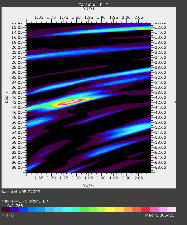
| Estimated Moho Depth: |
41.75 km |
| Estimated Crust Vp/Vs: |
1.76 |
| Assumed Crust Vp: |
6.498 km/s |
| Estimated Crust Vs: |
3.681 km/s |
| Estimated Crust Poisson's Ratio: |
0.26 |
|
| Radial Match: |
95.24008 % |
| Radial Bump: |
329 |
| Transverse Match: |
61.507698 % |
| Transverse Bump: |
400 |
| SOD ConfigId: |
469095 |
| Insert Time: |
2013-02-22 06:00:10.381 +0000 |
| GWidth: |
2.5 |
| Max Bumps: |
400 |
| Tol: |
0.001 |
|

Signal To Noise
| Channel | StoN | STA | LTA |
| TA:O41A: :BHZ:20120810T18:46:19.949985Z | 8.112969 | 6.294924E-7 | 7.7590876E-8 |
| TA:O41A: :BHN:20120810T18:46:19.949985Z | 3.0357192 | 2.7270676E-7 | 8.983267E-8 |
| TA:O41A: :BHE:20120810T18:46:19.949985Z | 3.3601687 | 3.0833772E-7 | 9.1762566E-8 |
| Arrivals |
| Ps | 5.2 SECOND |
| PpPs | 17 SECOND |
| PsPs/PpSs | 22 SECOND |


