You are here: Home > Network List > G - GEOSCOPE Stations List
> Station TAM Tamanrasset, Algeria > Earthquake Result Viewer
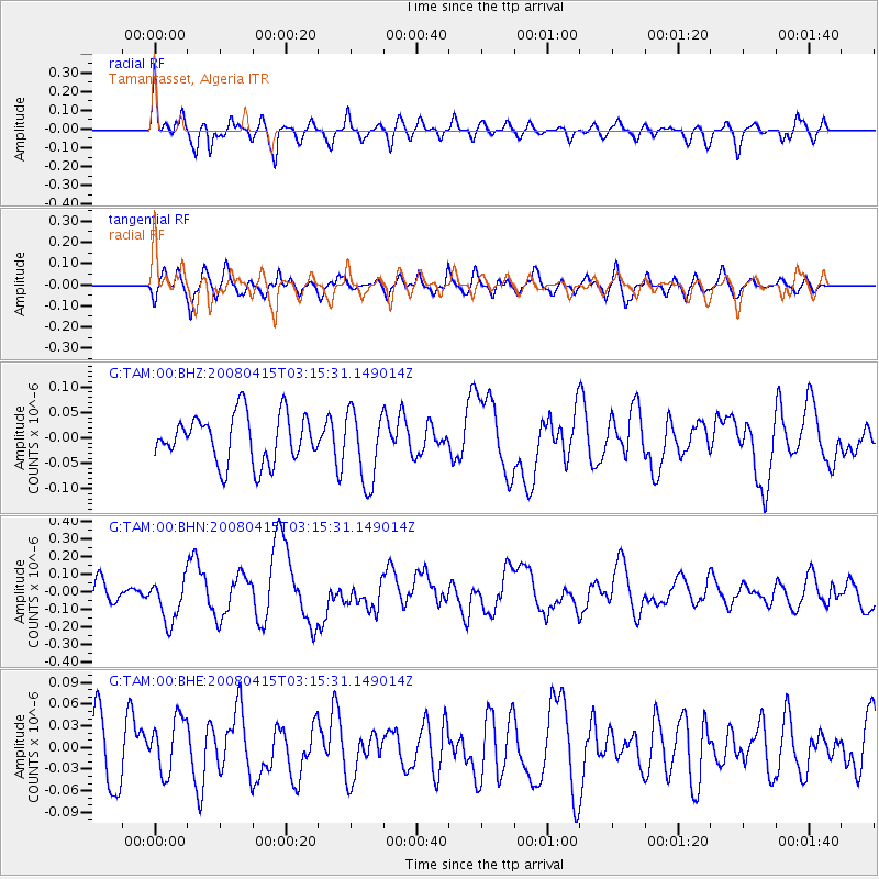
TAM Tamanrasset, Algeria - Earthquake Result Viewer
*The percent match for this event was below the threshold and hence no stack was calculated.
| Earthquake location: |
Near Coast Of Guatemala |
| Earthquake latitude/longitude: |
13.6/-90.6 |
| Earthquake time(UTC): |
2008/04/15 (106) 03:03:04 GMT |
| Earthquake Depth: |
33 km |
| Earthquake Magnitude: |
5.6 MB, 5.8 MS, 6.1 MW, 6.1 MW |
| Earthquake Catalog/Contributor: |
WHDF/NEIC |
|
| Network: |
G GEOSCOPE |
| Station: |
TAM Tamanrasset, Algeria |
| Lat/Lon: |
22.79 N/5.53 E |
| Elevation: |
1377 m |
|
| Distance: |
90.3 deg |
| Az: |
66.577 deg |
| Baz: |
284.776 deg |
| Ray Param: |
$rayparam |
*The percent match for this event was below the threshold and hence was not used in the summary stack. |
|
| Radial Match: |
70.81699 % |
| Radial Bump: |
400 |
| Transverse Match: |
61.673504 % |
| Transverse Bump: |
400 |
| SOD ConfigId: |
2504 |
| Insert Time: |
2010-02-27 00:34:52.130 +0000 |
| GWidth: |
2.5 |
| Max Bumps: |
400 |
| Tol: |
0.001 |
|
Signal To Noise
| Channel | StoN | STA | LTA |
| G:TAM:00:BHN:20080415T03:15:31.149014Z | 2.2518609 | 1.2499098E-7 | 5.550564E-8 |
| G:TAM:00:BHE:20080415T03:15:31.149014Z | 0.97151935 | 3.8548094E-8 | 3.9678156E-8 |
| G:TAM:00:BHZ:20080415T03:15:31.149014Z | 1.5175062 | 7.127694E-8 | 4.6969785E-8 |
| Arrivals |
| Ps | |
| PpPs | |
| PsPs/PpSs | |


