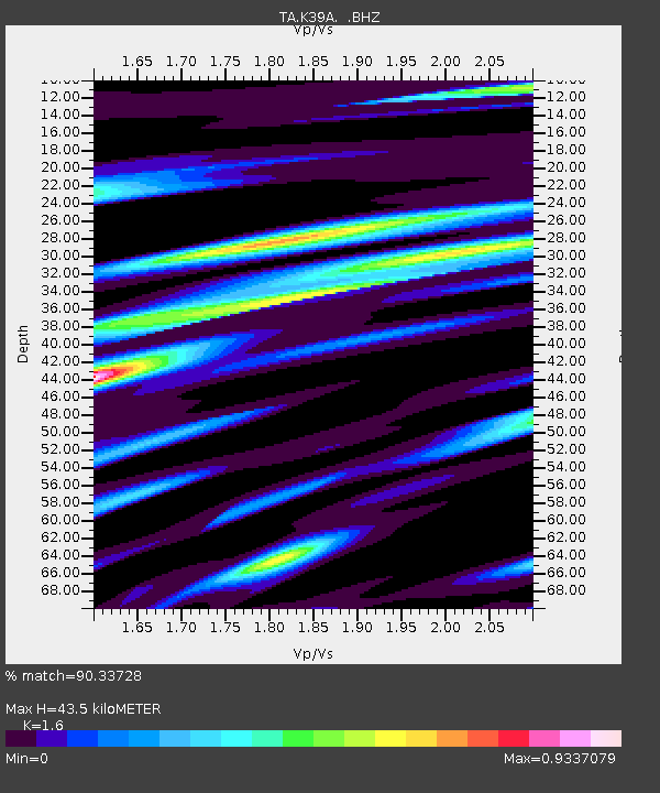
K39A Oelwein, IA, USA - Earthquake Result Viewer
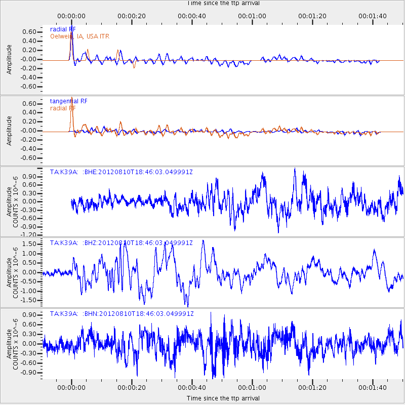
Earthquake location: Fox Islands, Aleutian Islands
Earthquake latitude/longitude: 52.6/-167.4
Earthquake time(UTC): 2012/08/10 (223) 18:37:43 GMT
Earthquake Depth: 13 km
Earthquake Magnitude: 5.9 MB, 6.2 MS, 6.2 MW, 6.2 MW
Earthquake Catalog/Contributor: WHDF/NEIC
Network: TA USArray Transportable Network (new EarthScope stations)
Station: K39A Oelwein, IA, USA
Lat/Lon: 42.71 N/91.89 W
Elevation: 332 m
Distance: 49.6 deg
Az: 69.569 deg
Baz: 309.209 deg
Ray Param: 0.06858294
Estimated Moho Depth: 43.5 km
Estimated Crust Vp/Vs: 1.60
Assumed Crust Vp: 6.53 km/s
Estimated Crust Vs: 4.082 km/s
Estimated Crust Poisson's Ratio: 0.18
Radial Match: 90.33728 %
Radial Bump: 400
Transverse Match: 70.8754 %
Transverse Bump: 400
SOD ConfigId: 469095
Insert Time: 2013-02-22 06:00:16.677 +0000
GWidth: 2.5
Max Bumps: 400
Tol: 0.001

Signal To Noise

ChannelStoNSTALTA
TA:K39A: :BHZ:20120810T18:46:03.049991Z4.58585365.0368817E-71.09835206E-7
TA:K39A: :BHN:20120810T18:46:03.049991Z1.71337582.1096957E-71.2313095E-7
TA:K39A: :BHE:20120810T18:46:03.049991Z1.59945212.2667268E-71.4171894E-7
Arrivals
Ps4.3 SECOND
PpPs16 SECOND
PsPs/PpSs20 SECOND