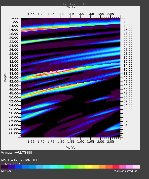
S42A Caledonia, MO, USA - Earthquake Result Viewer

Earthquake location: Fox Islands, Aleutian Islands
Earthquake latitude/longitude: 52.6/-167.4
Earthquake time(UTC): 2012/08/10 (223) 18:37:43 GMT
Earthquake Depth: 13 km
Earthquake Magnitude: 5.9 MB, 6.2 MS, 6.2 MW, 6.2 MW
Earthquake Catalog/Contributor: WHDF/NEIC
Network: TA USArray Transportable Network (new EarthScope stations)
Station: S42A Caledonia, MO, USA
Lat/Lon: 37.77 N/90.79 W
Elevation: 315 m
Distance: 53.5 deg
Az: 73.633 deg
Baz: 312.443 deg
Ray Param: 0.06607146
Estimated Moho Depth: 36.75 km
Estimated Crust Vp/Vs: 1.78
Assumed Crust Vp: 6.53 km/s
Estimated Crust Vs: 3.674 km/s
Estimated Crust Poisson's Ratio: 0.27
Radial Match: 92.75488 %
Radial Bump: 400
Transverse Match: 55.2386 %
Transverse Bump: 400
SOD ConfigId: 469095
Insert Time: 2013-02-22 06:01:22.400 +0000
GWidth: 2.5
Max Bumps: 400
Tol: 0.001

Signal To Noise

ChannelStoNSTALTA
TA:S42A: :BHZ:20120810T18:46:31.874973Z4.8972973.4934888E-77.133504E-8
TA:S42A: :BHN:20120810T18:46:31.874973Z1.31229781.5108765E-71.1513213E-7
TA:S42A: :BHE:20120810T18:46:31.874973Z3.9105632.548342E-76.516561E-8
Arrivals
Ps4.6 SECOND
PpPs15 SECOND
PsPs/PpSs19 SECOND