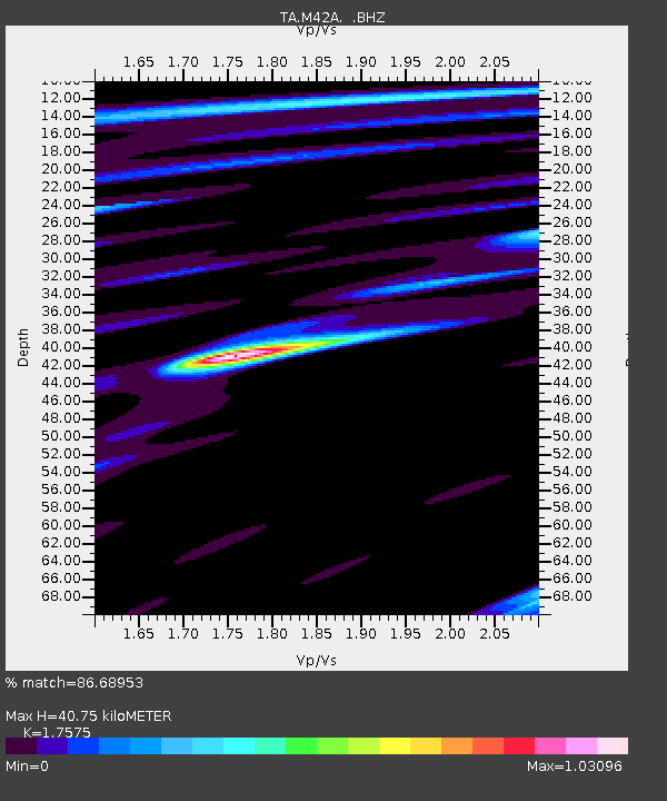
M42A Sheffield, IL, USA - Earthquake Result Viewer
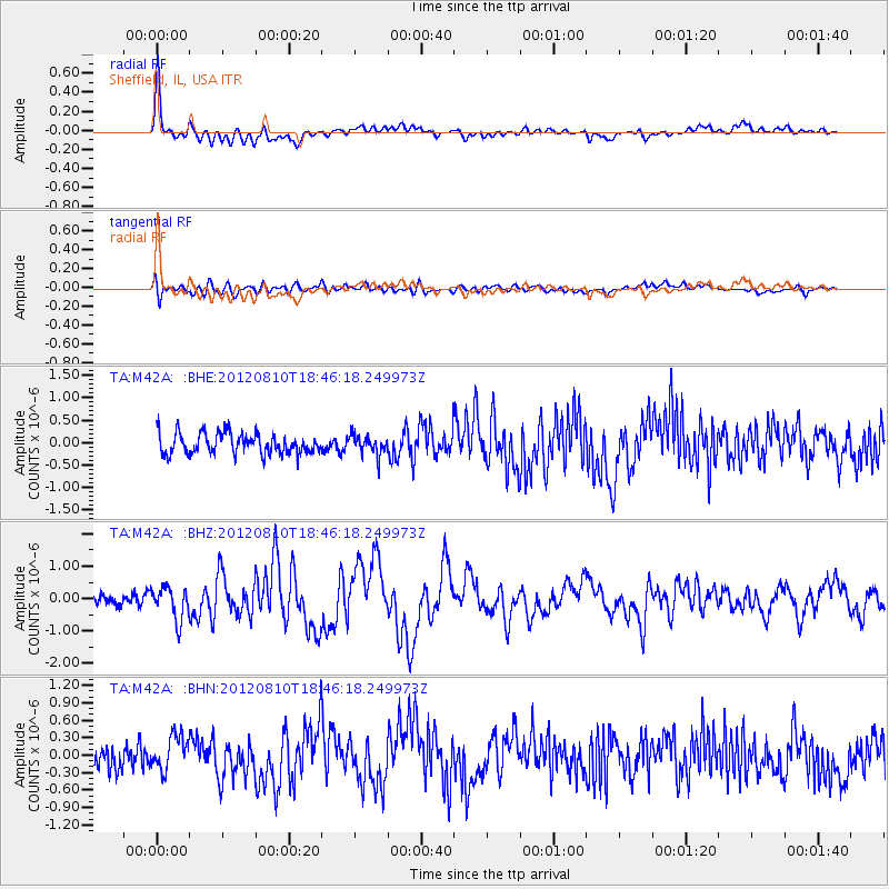
Earthquake location: Fox Islands, Aleutian Islands
Earthquake latitude/longitude: 52.6/-167.4
Earthquake time(UTC): 2012/08/10 (223) 18:37:43 GMT
Earthquake Depth: 13 km
Earthquake Magnitude: 5.9 MB, 6.2 MS, 6.2 MW, 6.2 MW
Earthquake Catalog/Contributor: WHDF/NEIC
Network: TA USArray Transportable Network (new EarthScope stations)
Station: M42A Sheffield, IL, USA
Lat/Lon: 41.45 N/89.76 W
Elevation: 212 m
Distance: 51.6 deg
Az: 69.493 deg
Baz: 310.584 deg
Ray Param: 0.06728217
Estimated Moho Depth: 40.75 km
Estimated Crust Vp/Vs: 1.76
Assumed Crust Vp: 6.498 km/s
Estimated Crust Vs: 3.697 km/s
Estimated Crust Poisson's Ratio: 0.26
Radial Match: 86.68953 %
Radial Bump: 400
Transverse Match: 59.316975 %
Transverse Bump: 400
SOD ConfigId: 469095
Insert Time: 2013-02-22 06:01:50.151 +0000
GWidth: 2.5
Max Bumps: 400
Tol: 0.001

Signal To Noise

ChannelStoNSTALTA
TA:M42A: :BHZ:20120810T18:46:18.249973Z2.75648365.0370363E-71.8273414E-7
TA:M42A: :BHN:20120810T18:46:18.249973Z1.60868982.8741644E-71.7866492E-7
TA:M42A: :BHE:20120810T18:46:18.249973Z1.00394832.2865494E-72.2775568E-7
Arrivals
Ps5.0 SECOND
PpPs16 SECOND
PsPs/PpSs21 SECOND