You are here: Home > Network List > TA - USArray Transportable Network (new EarthScope stations) Stations List
> Station P44A Sand Creek, Windsor, IL, USA > Earthquake Result Viewer
P44A Sand Creek, Windsor, IL, USA - Earthquake Result Viewer
| Earthquake location: |
Fox Islands, Aleutian Islands |
| Earthquake latitude/longitude: |
52.6/-167.4 |
| Earthquake time(UTC): |
2012/08/10 (223) 18:37:43 GMT |
| Earthquake Depth: |
13 km |
| Earthquake Magnitude: |
5.9 MB, 6.2 MS, 6.2 MW, 6.2 MW |
| Earthquake Catalog/Contributor: |
WHDF/NEIC |
|
| Network: |
TA USArray Transportable Network (new EarthScope stations) |
| Station: |
P44A Sand Creek, Windsor, IL, USA |
| Lat/Lon: |
39.47 N/88.62 W |
| Elevation: |
195 m |
|
| Distance: |
53.6 deg |
| Az: |
70.649 deg |
| Baz: |
312.021 deg |
| Ray Param: |
0.06599014 |
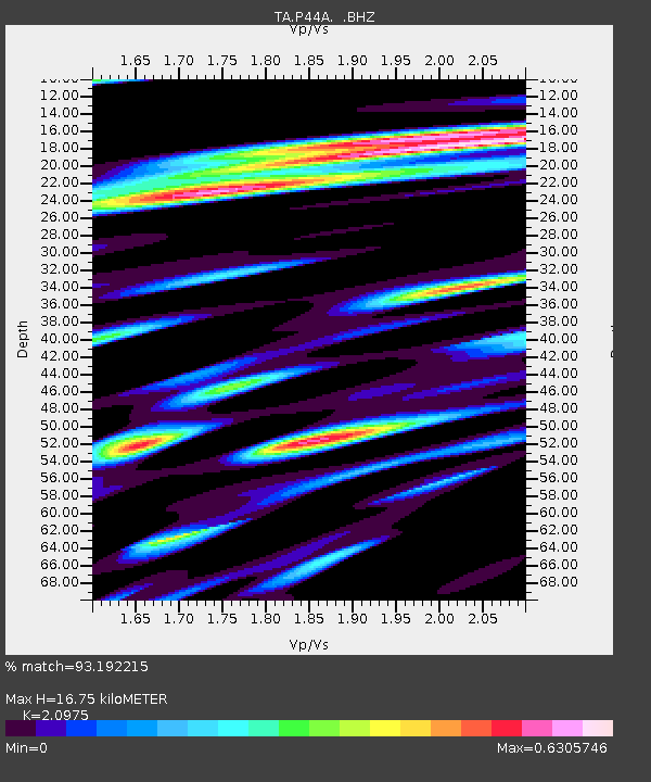
| Estimated Moho Depth: |
16.75 km |
| Estimated Crust Vp/Vs: |
2.10 |
| Assumed Crust Vp: |
6.444 km/s |
| Estimated Crust Vs: |
3.072 km/s |
| Estimated Crust Poisson's Ratio: |
0.35 |
|
| Radial Match: |
93.192215 % |
| Radial Bump: |
400 |
| Transverse Match: |
59.879574 % |
| Transverse Bump: |
400 |
| SOD ConfigId: |
469095 |
| Insert Time: |
2013-02-22 06:02:33.191 +0000 |
| GWidth: |
2.5 |
| Max Bumps: |
400 |
| Tol: |
0.001 |
|
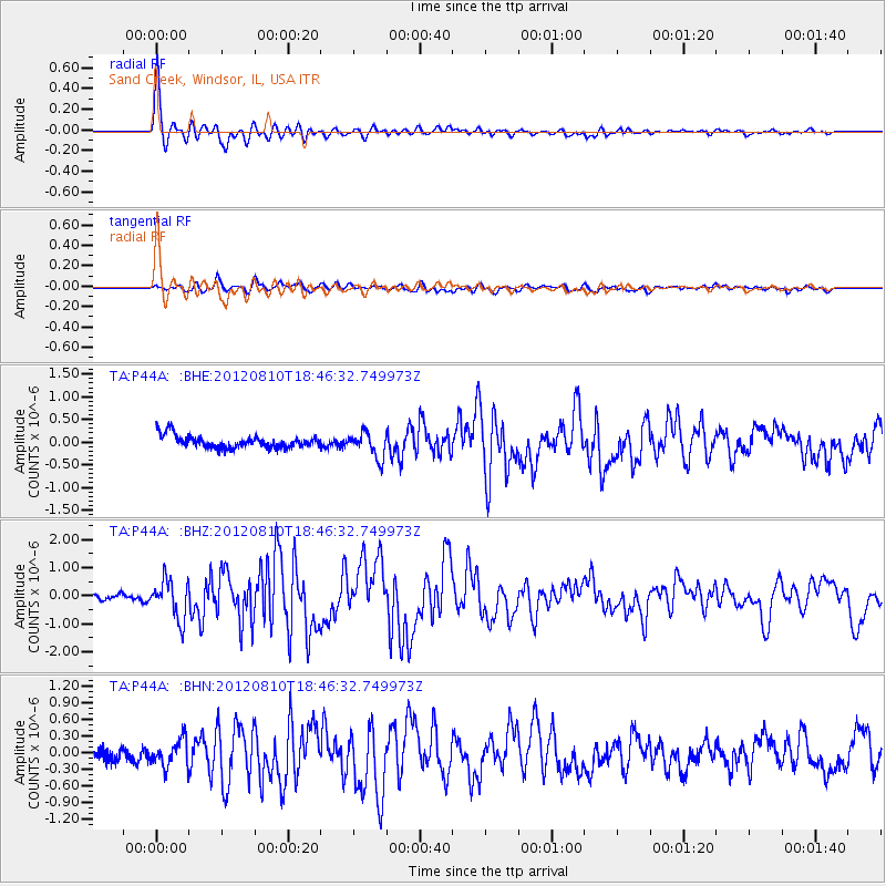
Signal To Noise
| Channel | StoN | STA | LTA |
| TA:P44A: :BHZ:20120810T18:46:32.749973Z | 6.6323266 | 6.9359135E-7 | 1.0457738E-7 |
| TA:P44A: :BHN:20120810T18:46:32.749973Z | 1.8367662 | 2.4280192E-7 | 1.3218988E-7 |
| TA:P44A: :BHE:20120810T18:46:32.749973Z | 2.0251997 | 2.8085094E-7 | 1.3867815E-7 |
| Arrivals |
| Ps | 3.0 SECOND |
| PpPs | 7.7 SECOND |
| PsPs/PpSs | 11 SECOND |


