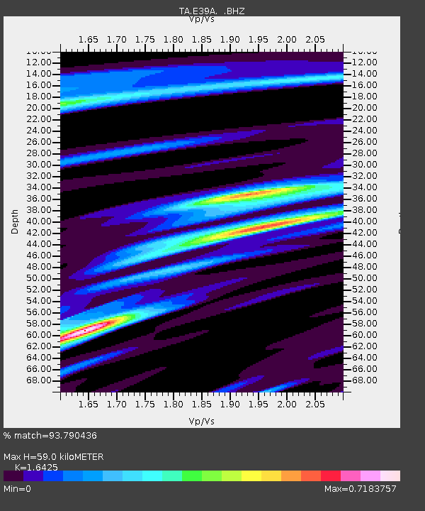
E39A Mellen, WI, USA - Earthquake Result Viewer
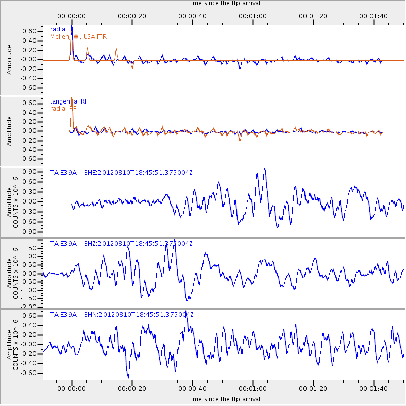
Earthquake location: Fox Islands, Aleutian Islands
Earthquake latitude/longitude: 52.6/-167.4
Earthquake time(UTC): 2012/08/10 (223) 18:37:43 GMT
Earthquake Depth: 13 km
Earthquake Magnitude: 5.9 MB, 6.2 MS, 6.2 MW, 6.2 MW
Earthquake Catalog/Contributor: WHDF/NEIC
Network: TA USArray Transportable Network (new EarthScope stations)
Station: E39A Mellen, WI, USA
Lat/Lon: 46.38 N/90.56 W
Elevation: 426 m
Distance: 48.1 deg
Az: 64.952 deg
Baz: 307.102 deg
Ray Param: 0.069572344
Estimated Moho Depth: 59.0 km
Estimated Crust Vp/Vs: 1.64
Assumed Crust Vp: 6.467 km/s
Estimated Crust Vs: 3.937 km/s
Estimated Crust Poisson's Ratio: 0.21
Radial Match: 93.790436 %
Radial Bump: 400
Transverse Match: 75.635635 %
Transverse Bump: 400
SOD ConfigId: 469095
Insert Time: 2013-02-22 06:04:10.185 +0000
GWidth: 2.5
Max Bumps: 400
Tol: 0.001

Signal To Noise

ChannelStoNSTALTA
TA:E39A: :BHZ:20120810T18:45:51.375004Z3.77554063.7500348E-79.9324446E-8
TA:E39A: :BHN:20120810T18:45:51.375004Z1.7819761.3862956E-77.779541E-8
TA:E39A: :BHE:20120810T18:45:51.375004Z2.4421371.6782421E-76.8720226E-8
Arrivals
Ps6.3 SECOND
PpPs23 SECOND
PsPs/PpSs29 SECOND