G43A Wallace, MI, USA - Earthquake Result Viewer
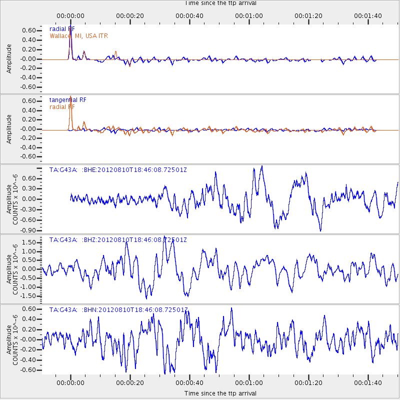
Earthquake location: Fox Islands, Aleutian Islands
Earthquake latitude/longitude: 52.6/-167.4
Earthquake time(UTC): 2012/08/10 (223) 18:37:43 GMT
Earthquake Depth: 13 km
Earthquake Magnitude: 5.9 MB, 6.2 MS, 6.2 MW, 6.2 MW
Earthquake Catalog/Contributor: WHDF/NEIC
Network: TA USArray Transportable Network (new EarthScope stations)
Station: G43A Wallace, MI, USA
Lat/Lon: 45.26 N/87.69 W
Elevation: 213 m
Distance: 50.4 deg
Az: 64.488 deg
Baz: 308.85 deg
Ray Param: 0.06810084
Estimated Moho Depth: 35.25 km
Estimated Crust Vp/Vs: 1.80
Assumed Crust Vp: 6.53 km/s
Estimated Crust Vs: 3.638 km/s
Estimated Crust Poisson's Ratio: 0.27
Radial Match: 93.835434 %
Radial Bump: 365
Transverse Match: 53.600395 %
Transverse Bump: 400
SOD ConfigId: 469095
Insert Time: 2013-02-22 06:04:42.046 +0000
GWidth: 2.5
Max Bumps: 400
Tol: 0.001

Signal To Noise

ChannelStoNSTALTA
TA:G43A: :BHZ:20120810T18:46:08.72501Z1.7627433.28E-71.8607363E-7
TA:G43A: :BHN:20120810T18:46:08.72501Z1.00063861.2446763E-71.2438818E-7
TA:G43A: :BHE:20120810T18:46:08.72501Z2.78470542.1004233E-77.542713E-8
Arrivals
Ps4.6 SECOND
PpPs14 SECOND
PsPs/PpSs19 SECOND