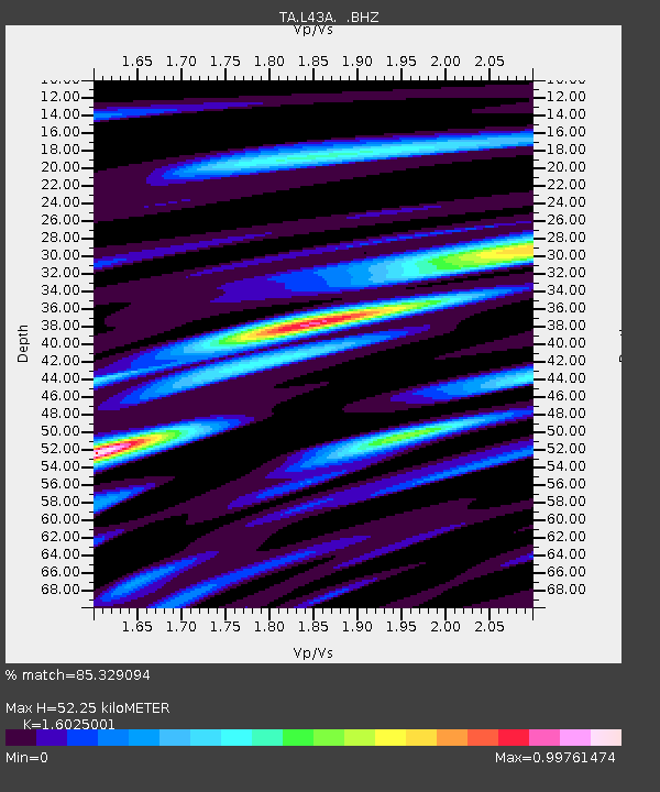
L43A Garden Prairie, IL, USA - Earthquake Result Viewer
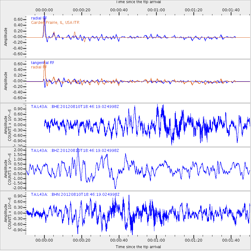
Earthquake location: Fox Islands, Aleutian Islands
Earthquake latitude/longitude: 52.6/-167.4
Earthquake time(UTC): 2012/08/10 (223) 18:37:43 GMT
Earthquake Depth: 13 km
Earthquake Magnitude: 5.9 MB, 6.2 MS, 6.2 MW, 6.2 MW
Earthquake Catalog/Contributor: WHDF/NEIC
Network: TA USArray Transportable Network (new EarthScope stations)
Station: L43A Garden Prairie, IL, USA
Lat/Lon: 42.18 N/88.74 W
Elevation: 266 m
Distance: 51.7 deg
Az: 68.159 deg
Baz: 310.431 deg
Ray Param: 0.06721278
Estimated Moho Depth: 52.25 km
Estimated Crust Vp/Vs: 1.60
Assumed Crust Vp: 6.571 km/s
Estimated Crust Vs: 4.1 km/s
Estimated Crust Poisson's Ratio: 0.18
Radial Match: 85.329094 %
Radial Bump: 400
Transverse Match: 68.40902 %
Transverse Bump: 400
SOD ConfigId: 469095
Insert Time: 2013-02-22 06:04:53.631 +0000
GWidth: 2.5
Max Bumps: 400
Tol: 0.001

Signal To Noise

ChannelStoNSTALTA
TA:L43A: :BHZ:20120810T18:46:19.024998Z1.92099064.505344E-72.3453232E-7
TA:L43A: :BHN:20120810T18:46:19.024998Z1.14484482.0136542E-71.7588884E-7
TA:L43A: :BHE:20120810T18:46:19.024998Z1.62566952.9785284E-71.8321857E-7
Arrivals
Ps5.1 SECOND
PpPs19 SECOND
PsPs/PpSs24 SECOND