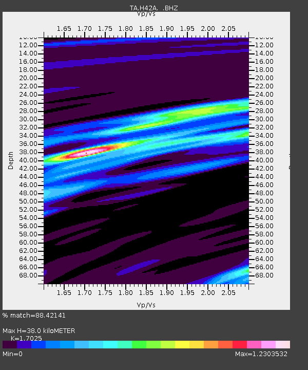
H42A Shiocton, WI, USA - Earthquake Result Viewer

Earthquake location: Fox Islands, Aleutian Islands
Earthquake latitude/longitude: 52.6/-167.4
Earthquake time(UTC): 2012/08/10 (223) 18:37:43 GMT
Earthquake Depth: 13 km
Earthquake Magnitude: 5.9 MB, 6.2 MS, 6.2 MW, 6.2 MW
Earthquake Catalog/Contributor: WHDF/NEIC
Network: TA USArray Transportable Network (new EarthScope stations)
Station: H42A Shiocton, WI, USA
Lat/Lon: 44.51 N/88.53 W
Elevation: 244 m
Distance: 50.4 deg
Az: 65.734 deg
Baz: 309.051 deg
Ray Param: 0.068098776
Estimated Moho Depth: 38.0 km
Estimated Crust Vp/Vs: 1.70
Assumed Crust Vp: 6.41 km/s
Estimated Crust Vs: 3.765 km/s
Estimated Crust Poisson's Ratio: 0.24
Radial Match: 88.42141 %
Radial Bump: 400
Transverse Match: 55.63968 %
Transverse Bump: 400
SOD ConfigId: 469095
Insert Time: 2013-02-22 06:05:31.401 +0000
GWidth: 2.5
Max Bumps: 400
Tol: 0.001

Signal To Noise

ChannelStoNSTALTA
TA:H42A: :BHZ:20120810T18:46:08.750004Z4.1738295.432832E-71.3016422E-7
TA:H42A: :BHN:20120810T18:46:08.750004Z1.23685424.514562E-73.650036E-7
TA:H42A: :BHE:20120810T18:46:08.750004Z1.72614914.3842888E-72.5399248E-7
Arrivals
Ps4.4 SECOND
PpPs15 SECOND
PsPs/PpSs20 SECOND