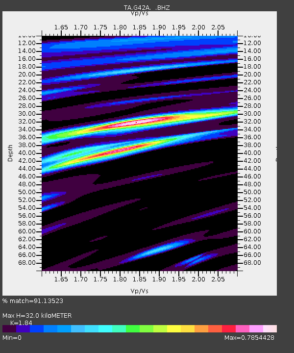
G42A Mountain, WI, USA - Earthquake Result Viewer
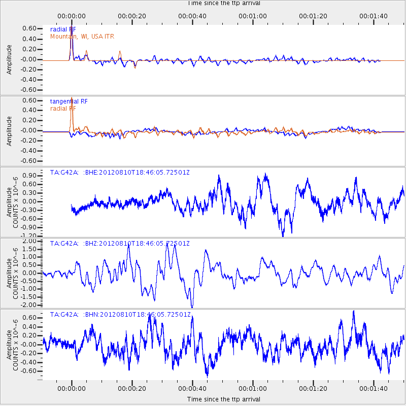
Earthquake location: Fox Islands, Aleutian Islands
Earthquake latitude/longitude: 52.6/-167.4
Earthquake time(UTC): 2012/08/10 (223) 18:37:43 GMT
Earthquake Depth: 13 km
Earthquake Magnitude: 5.9 MB, 6.2 MS, 6.2 MW, 6.2 MW
Earthquake Catalog/Contributor: WHDF/NEIC
Network: TA USArray Transportable Network (new EarthScope stations)
Station: G42A Mountain, WI, USA
Lat/Lon: 45.24 N/88.43 W
Elevation: 315 m
Distance: 50.0 deg
Az: 64.93 deg
Baz: 308.609 deg
Ray Param: 0.06835929
Estimated Moho Depth: 32.0 km
Estimated Crust Vp/Vs: 1.84
Assumed Crust Vp: 6.41 km/s
Estimated Crust Vs: 3.484 km/s
Estimated Crust Poisson's Ratio: 0.29
Radial Match: 91.13523 %
Radial Bump: 400
Transverse Match: 68.0724 %
Transverse Bump: 400
SOD ConfigId: 469095
Insert Time: 2013-02-22 06:05:39.731 +0000
GWidth: 2.5
Max Bumps: 400
Tol: 0.001

Signal To Noise

ChannelStoNSTALTA
TA:G42A: :BHZ:20120810T18:46:05.72501Z3.24783644.4980462E-71.3849362E-7
TA:G42A: :BHN:20120810T18:46:05.72501Z0.81292031.5051911E-71.8515853E-7
TA:G42A: :BHE:20120810T18:46:05.72501Z2.70042663.266342E-71.2095651E-7
Arrivals
Ps4.4 SECOND
PpPs13 SECOND
PsPs/PpSs18 SECOND