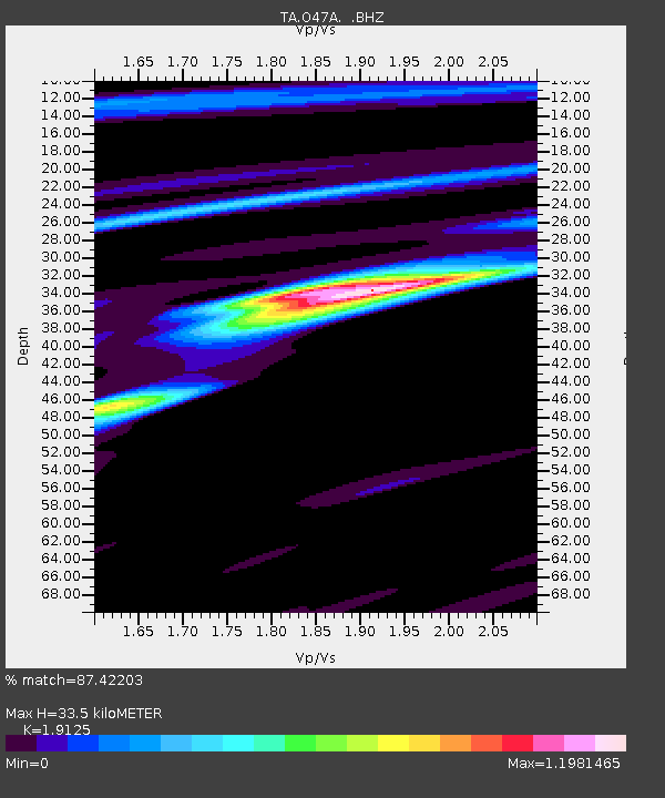
O47A Sheridan, IN, USA - Earthquake Result Viewer
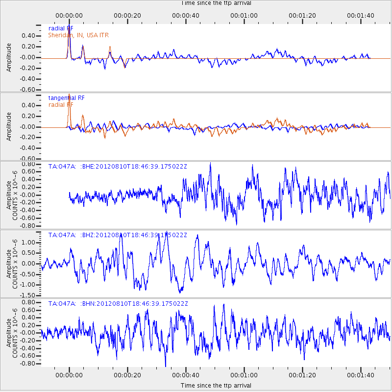
Earthquake location: Fox Islands, Aleutian Islands
Earthquake latitude/longitude: 52.6/-167.4
Earthquake time(UTC): 2012/08/10 (223) 18:37:43 GMT
Earthquake Depth: 13 km
Earthquake Magnitude: 5.9 MB, 6.2 MS, 6.2 MW, 6.2 MW
Earthquake Catalog/Contributor: WHDF/NEIC
Network: TA USArray Transportable Network (new EarthScope stations)
Station: O47A Sheridan, IN, USA
Lat/Lon: 40.24 N/86.17 W
Elevation: 278 m
Distance: 54.5 deg
Az: 68.385 deg
Baz: 312.252 deg
Ray Param: 0.065419436
Estimated Moho Depth: 33.5 km
Estimated Crust Vp/Vs: 1.91
Assumed Crust Vp: 6.498 km/s
Estimated Crust Vs: 3.397 km/s
Estimated Crust Poisson's Ratio: 0.31
Radial Match: 87.42203 %
Radial Bump: 400
Transverse Match: 71.622116 %
Transverse Bump: 400
SOD ConfigId: 469095
Insert Time: 2013-02-22 06:07:03.781 +0000
GWidth: 2.5
Max Bumps: 400
Tol: 0.001

Signal To Noise

ChannelStoNSTALTA
TA:O47A: :BHZ:20120810T18:46:39.175022Z4.16786344.3840282E-71.0518647E-7
TA:O47A: :BHN:20120810T18:46:39.175022Z1.36059651.412442E-71.038105E-7
TA:O47A: :BHE:20120810T18:46:39.175022Z1.90481211.739339E-79.13129E-8
Arrivals
Ps4.9 SECOND
PpPs14 SECOND
PsPs/PpSs19 SECOND