You are here: Home > Network List > TA - USArray Transportable Network (new EarthScope stations) Stations List
> Station R46A Gibon Southern Titans, Haubstabt, IN, USA > Earthquake Result Viewer
R46A Gibon Southern Titans, Haubstabt, IN, USA - Earthquake Result Viewer
| Earthquake location: |
Fox Islands, Aleutian Islands |
| Earthquake latitude/longitude: |
52.6/-167.4 |
| Earthquake time(UTC): |
2012/08/10 (223) 18:37:43 GMT |
| Earthquake Depth: |
13 km |
| Earthquake Magnitude: |
5.9 MB, 6.2 MS, 6.2 MW, 6.2 MW |
| Earthquake Catalog/Contributor: |
WHDF/NEIC |
|
| Network: |
TA USArray Transportable Network (new EarthScope stations) |
| Station: |
R46A Gibon Southern Titans, Haubstabt, IN, USA |
| Lat/Lon: |
38.21 N/87.51 W |
| Elevation: |
164 m |
|
| Distance: |
55.1 deg |
| Az: |
71.066 deg |
| Baz: |
312.957 deg |
| Ray Param: |
0.065025784 |
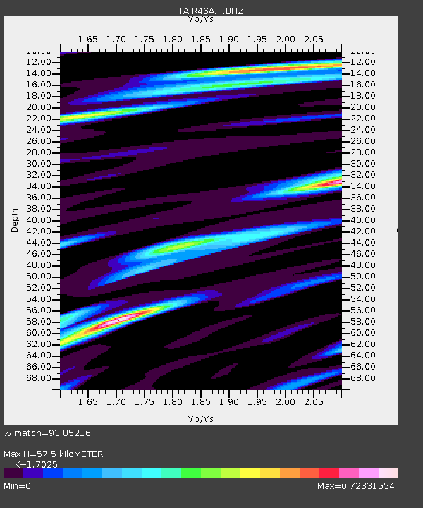
| Estimated Moho Depth: |
57.5 km |
| Estimated Crust Vp/Vs: |
1.70 |
| Assumed Crust Vp: |
6.444 km/s |
| Estimated Crust Vs: |
3.785 km/s |
| Estimated Crust Poisson's Ratio: |
0.24 |
|
| Radial Match: |
93.85216 % |
| Radial Bump: |
386 |
| Transverse Match: |
66.96437 % |
| Transverse Bump: |
400 |
| SOD ConfigId: |
469095 |
| Insert Time: |
2013-02-22 06:07:50.523 +0000 |
| GWidth: |
2.5 |
| Max Bumps: |
400 |
| Tol: |
0.001 |
|

Signal To Noise
| Channel | StoN | STA | LTA |
| TA:R46A: :BHZ:20120810T18:46:43.524998Z | 4.914321 | 5.0457203E-7 | 1.026738E-7 |
| TA:R46A: :BHN:20120810T18:46:43.524998Z | 1.445733 | 2.3444566E-7 | 1.6216389E-7 |
| TA:R46A: :BHE:20120810T18:46:43.524998Z | 1.7754945 | 2.488636E-7 | 1.4016581E-7 |
| Arrivals |
| Ps | 6.6 SECOND |
| PpPs | 23 SECOND |
| PsPs/PpSs | 29 SECOND |


