You are here: Home > Network List > TA - USArray Transportable Network (new EarthScope stations) Stations List
> Station P45A Graceland, Paris, IL, USA > Earthquake Result Viewer
P45A Graceland, Paris, IL, USA - Earthquake Result Viewer

| Earthquake location: |
Fox Islands, Aleutian Islands |
| Earthquake latitude/longitude: |
52.6/-167.4 |
| Earthquake time(UTC): |
2012/08/10 (223) 18:37:43 GMT |
| Earthquake Depth: |
13 km |
| Earthquake Magnitude: |
5.9 MB, 6.2 MS, 6.2 MW, 6.2 MW |
| Earthquake Catalog/Contributor: |
WHDF/NEIC |
|
| Network: |
TA USArray Transportable Network (new EarthScope stations) |
| Station: |
P45A Graceland, Paris, IL, USA |
| Lat/Lon: |
39.53 N/87.74 W |
| Elevation: |
193 m |
|
| Distance: |
54.1 deg |
| Az: |
70.03 deg |
| Baz: |
312.211 deg |
| Ray Param: |
0.06568087 |
| Estimated Moho Depth: |
38.5 km |
| Estimated Crust Vp/Vs: |
1.98 |
| Assumed Crust Vp: |
6.444 km/s |
| Estimated Crust Vs: |
3.25 km/s |
| Estimated Crust Poisson's Ratio: |
0.33 |
|
| Radial Match: |
90.144775 % |
| Radial Bump: |
400 |
| Transverse Match: |
50.978092 % |
| Transverse Bump: |
400 |
| SOD ConfigId: |
469095 |
| Insert Time: |
2013-02-22 06:07:59.025 +0000 |
| GWidth: |
2.5 |
| Max Bumps: |
400 |
| Tol: |
0.001 |
|
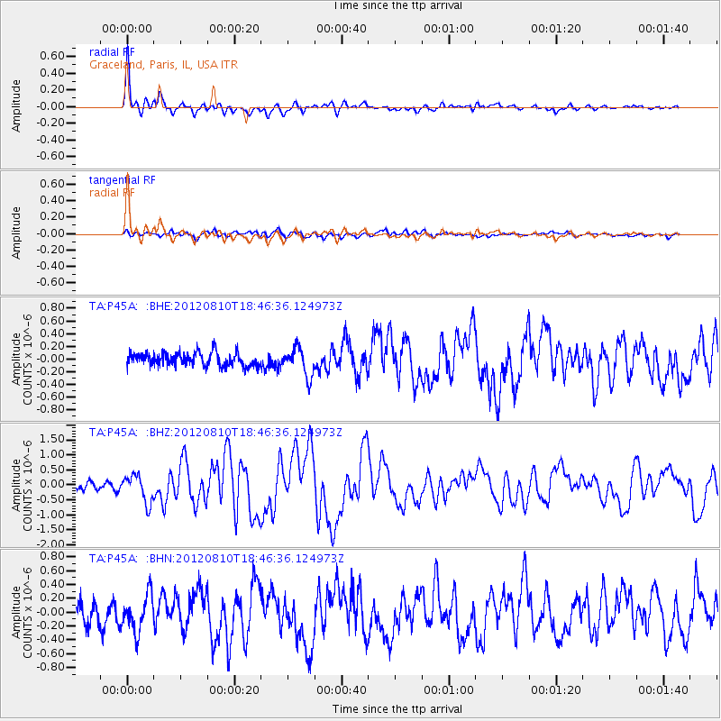
Signal To Noise
| Channel | StoN | STA | LTA |
| TA:P45A: :BHZ:20120810T18:46:36.124973Z | 4.03377 | 4.592843E-7 | 1.1385981E-7 |
| TA:P45A: :BHN:20120810T18:46:36.124973Z | 2.1844275 | 2.603893E-7 | 1.1920254E-7 |
| TA:P45A: :BHE:20120810T18:46:36.124973Z | 2.1291685 | 2.2162193E-7 | 1.0408849E-7 |
| Arrivals |
| Ps | 6.2 SECOND |
| PpPs | 17 SECOND |
| PsPs/PpSs | 23 SECOND |


