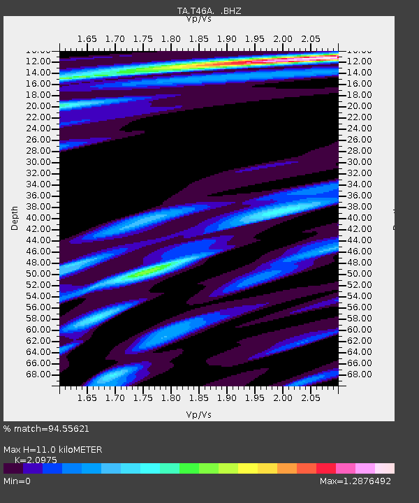
T46A Princeton, KY, USA - Earthquake Result Viewer
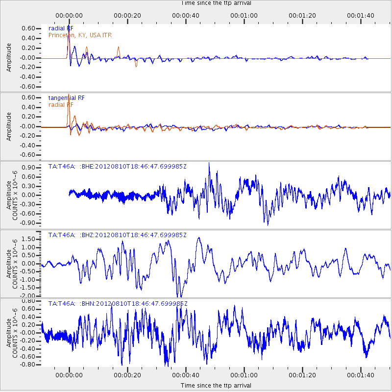
Earthquake location: Fox Islands, Aleutian Islands
Earthquake latitude/longitude: 52.6/-167.4
Earthquake time(UTC): 2012/08/10 (223) 18:37:43 GMT
Earthquake Depth: 13 km
Earthquake Magnitude: 5.9 MB, 6.2 MS, 6.2 MW, 6.2 MW
Earthquake Catalog/Contributor: WHDF/NEIC
Network: TA USArray Transportable Network (new EarthScope stations)
Station: T46A Princeton, KY, USA
Lat/Lon: 37.04 N/87.89 W
Elevation: 169 m
Distance: 55.7 deg
Az: 72.355 deg
Baz: 313.457 deg
Ray Param: 0.06464488
Estimated Moho Depth: 11.0 km
Estimated Crust Vp/Vs: 2.10
Assumed Crust Vp: 6.444 km/s
Estimated Crust Vs: 3.072 km/s
Estimated Crust Poisson's Ratio: 0.35
Radial Match: 94.55621 %
Radial Bump: 400
Transverse Match: 68.016754 %
Transverse Bump: 400
SOD ConfigId: 469095
Insert Time: 2013-02-22 06:08:02.519 +0000
GWidth: 2.5
Max Bumps: 400
Tol: 0.001

Signal To Noise

ChannelStoNSTALTA
TA:T46A: :BHZ:20120810T18:46:47.699985Z5.3746764.5929912E-78.545614E-8
TA:T46A: :BHN:20120810T18:46:47.699985Z2.1568862.2349155E-71.0361769E-7
TA:T46A: :BHE:20120810T18:46:47.699985Z2.26809242.0128017E-78.874426E-8
Arrivals
Ps2.0 SECOND
PpPs5.1 SECOND
PsPs/PpSs7.0 SECOND