You are here: Home > Network List > TA - USArray Transportable Network (new EarthScope stations) Stations List
> Station S46A Don Dixon Farm, Corydon, KY, USA > Earthquake Result Viewer
S46A Don Dixon Farm, Corydon, KY, USA - Earthquake Result Viewer
| Earthquake location: |
Fox Islands, Aleutian Islands |
| Earthquake latitude/longitude: |
52.6/-167.4 |
| Earthquake time(UTC): |
2012/08/10 (223) 18:37:43 GMT |
| Earthquake Depth: |
13 km |
| Earthquake Magnitude: |
5.9 MB, 6.2 MS, 6.2 MW, 6.2 MW |
| Earthquake Catalog/Contributor: |
WHDF/NEIC |
|
| Network: |
TA USArray Transportable Network (new EarthScope stations) |
| Station: |
S46A Don Dixon Farm, Corydon, KY, USA |
| Lat/Lon: |
37.68 N/87.72 W |
| Elevation: |
125 m |
|
| Distance: |
55.3 deg |
| Az: |
71.669 deg |
| Baz: |
313.176 deg |
| Ray Param: |
0.064864196 |
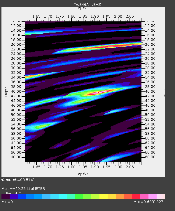
| Estimated Moho Depth: |
40.25 km |
| Estimated Crust Vp/Vs: |
1.91 |
| Assumed Crust Vp: |
6.444 km/s |
| Estimated Crust Vs: |
3.365 km/s |
| Estimated Crust Poisson's Ratio: |
0.31 |
|
| Radial Match: |
93.5141 % |
| Radial Bump: |
400 |
| Transverse Match: |
66.20272 % |
| Transverse Bump: |
400 |
| SOD ConfigId: |
469095 |
| Insert Time: |
2013-02-22 06:08:22.933 +0000 |
| GWidth: |
2.5 |
| Max Bumps: |
400 |
| Tol: |
0.001 |
|

Signal To Noise
| Channel | StoN | STA | LTA |
| TA:S46A: :BHZ:20120810T18:46:45.274998Z | 4.211528 | 4.1362725E-7 | 9.821311E-8 |
| TA:S46A: :BHN:20120810T18:46:45.274998Z | 2.3370461 | 1.9060961E-7 | 8.156006E-8 |
| TA:S46A: :BHE:20120810T18:46:45.274998Z | 2.342725 | 1.8972676E-7 | 8.09855E-8 |
| Arrivals |
| Ps | 6.0 SECOND |
| PpPs | 17 SECOND |
| PsPs/PpSs | 23 SECOND |


