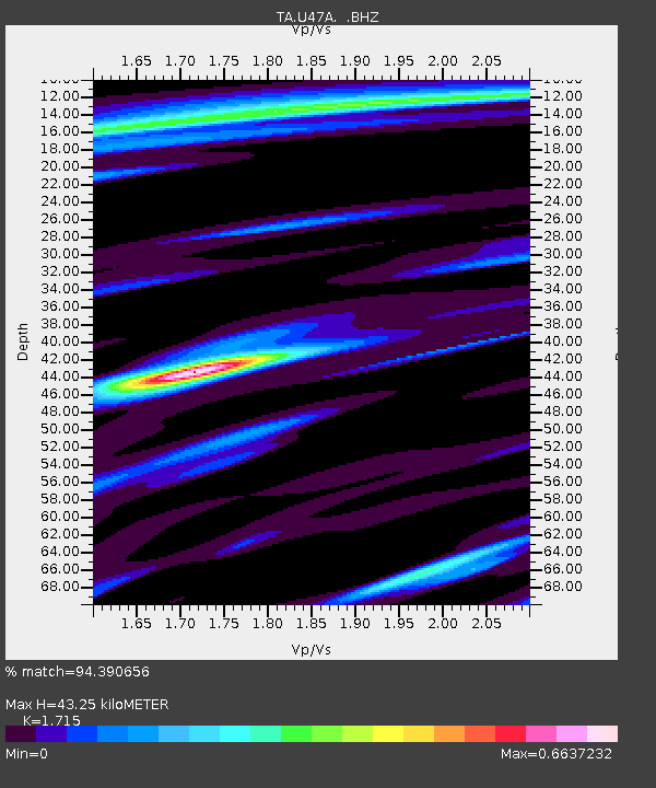
U47A Clarksville, TN, USA - Earthquake Result Viewer

Earthquake location: Fox Islands, Aleutian Islands
Earthquake latitude/longitude: 52.6/-167.4
Earthquake time(UTC): 2012/08/10 (223) 18:37:43 GMT
Earthquake Depth: 13 km
Earthquake Magnitude: 5.9 MB, 6.2 MS, 6.2 MW, 6.2 MW
Earthquake Catalog/Contributor: WHDF/NEIC
Network: TA USArray Transportable Network (new EarthScope stations)
Station: U47A Clarksville, TN, USA
Lat/Lon: 36.44 N/87.29 W
Elevation: 145 m
Distance: 56.4 deg
Az: 72.473 deg
Baz: 313.883 deg
Ray Param: 0.06414661
Estimated Moho Depth: 43.25 km
Estimated Crust Vp/Vs: 1.72
Assumed Crust Vp: 6.444 km/s
Estimated Crust Vs: 3.757 km/s
Estimated Crust Poisson's Ratio: 0.24
Radial Match: 94.390656 %
Radial Bump: 370
Transverse Match: 69.88343 %
Transverse Bump: 400
SOD ConfigId: 469095
Insert Time: 2013-02-22 06:08:34.257 +0000
GWidth: 2.5
Max Bumps: 400
Tol: 0.001

Signal To Noise

ChannelStoNSTALTA
TA:U47A: :BHZ:20120810T18:46:53.175022Z9.9941554.5198186E-74.5224624E-8
TA:U47A: :BHN:20120810T18:46:53.175022Z0.72838371.2862237E-71.7658601E-7
TA:U47A: :BHE:20120810T18:46:53.175022Z2.1244151.5980028E-77.5220846E-8
Arrivals
Ps5.1 SECOND
PpPs17 SECOND
PsPs/PpSs22 SECOND