You are here: Home > Network List > TA - USArray Transportable Network (new EarthScope stations) Stations List
> Station S48A Wiedeman Farm, Cecilia, KY, USA > Earthquake Result Viewer
S48A Wiedeman Farm, Cecilia, KY, USA - Earthquake Result Viewer
| Earthquake location: |
Fox Islands, Aleutian Islands |
| Earthquake latitude/longitude: |
52.6/-167.4 |
| Earthquake time(UTC): |
2012/08/10 (223) 18:37:43 GMT |
| Earthquake Depth: |
13 km |
| Earthquake Magnitude: |
5.9 MB, 6.2 MS, 6.2 MW, 6.2 MW |
| Earthquake Catalog/Contributor: |
WHDF/NEIC |
|
| Network: |
TA USArray Transportable Network (new EarthScope stations) |
| Station: |
S48A Wiedeman Farm, Cecilia, KY, USA |
| Lat/Lon: |
37.66 N/86.06 W |
| Elevation: |
238 m |
|
| Distance: |
56.3 deg |
| Az: |
70.6 deg |
| Baz: |
313.585 deg |
| Ray Param: |
0.06422912 |
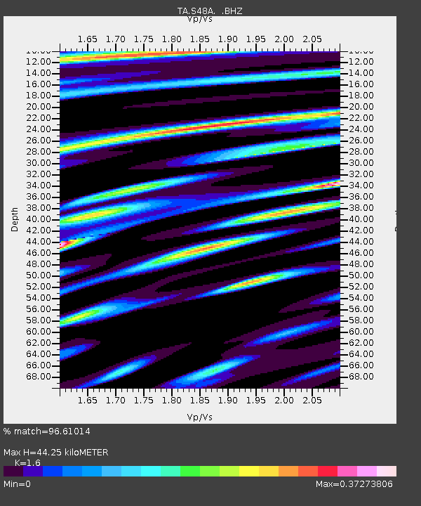
| Estimated Moho Depth: |
44.25 km |
| Estimated Crust Vp/Vs: |
1.60 |
| Assumed Crust Vp: |
6.444 km/s |
| Estimated Crust Vs: |
4.027 km/s |
| Estimated Crust Poisson's Ratio: |
0.18 |
|
| Radial Match: |
96.61014 % |
| Radial Bump: |
358 |
| Transverse Match: |
69.28399 % |
| Transverse Bump: |
400 |
| SOD ConfigId: |
469095 |
| Insert Time: |
2013-02-22 06:08:36.749 +0000 |
| GWidth: |
2.5 |
| Max Bumps: |
400 |
| Tol: |
0.001 |
|
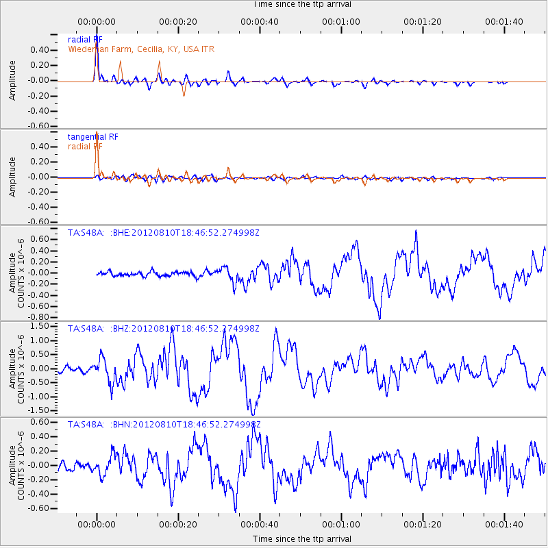
Signal To Noise
| Channel | StoN | STA | LTA |
| TA:S48A: :BHZ:20120810T18:46:52.274998Z | 5.359796 | 4.3228243E-7 | 8.065278E-8 |
| TA:S48A: :BHN:20120810T18:46:52.274998Z | 3.0202014 | 1.4035474E-7 | 4.647198E-8 |
| TA:S48A: :BHE:20120810T18:46:52.274998Z | 3.6137276 | 1.35833E-7 | 3.758806E-8 |
| Arrivals |
| Ps | 4.4 SECOND |
| PpPs | 17 SECOND |
| PsPs/PpSs | 21 SECOND |


