X46A Booneville, MS, USA - Earthquake Result Viewer
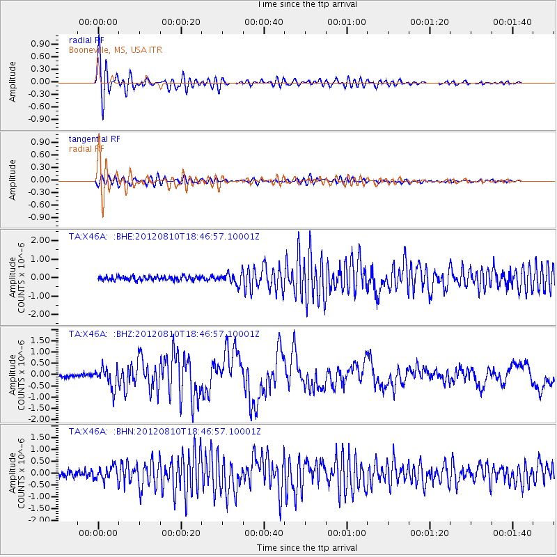
Earthquake location: Fox Islands, Aleutian Islands
Earthquake latitude/longitude: 52.6/-167.4
Earthquake time(UTC): 2012/08/10 (223) 18:37:43 GMT
Earthquake Depth: 13 km
Earthquake Magnitude: 5.9 MB, 6.2 MS, 6.2 MW, 6.2 MW
Earthquake Catalog/Contributor: WHDF/NEIC
Network: TA USArray Transportable Network (new EarthScope stations)
Station: X46A Booneville, MS, USA
Lat/Lon: 34.56 N/88.58 W
Elevation: 150 m
Distance: 57.0 deg
Az: 74.968 deg
Baz: 314.504 deg
Ray Param: 0.06378382
Estimated Moho Depth: 20.25 km
Estimated Crust Vp/Vs: 1.60
Assumed Crust Vp: 6.38 km/s
Estimated Crust Vs: 3.982 km/s
Estimated Crust Poisson's Ratio: 0.18
Radial Match: 96.054436 %
Radial Bump: 400
Transverse Match: 87.07495 %
Transverse Bump: 400
SOD ConfigId: 469095
Insert Time: 2013-02-22 06:08:45.926 +0000
GWidth: 2.5
Max Bumps: 400
Tol: 0.001

Signal To Noise

ChannelStoNSTALTA
TA:X46A: :BHZ:20120810T18:46:57.10001Z6.47685864.5612288E-77.0423475E-8
TA:X46A: :BHN:20120810T18:46:57.10001Z2.51653392.9540197E-71.1738446E-7
TA:X46A: :BHE:20120810T18:46:57.10001Z2.79540132.9997594E-71.0731051E-7
Arrivals
Ps2.0 SECOND
PpPs7.8 SECOND
PsPs/PpSs9.8 SECOND