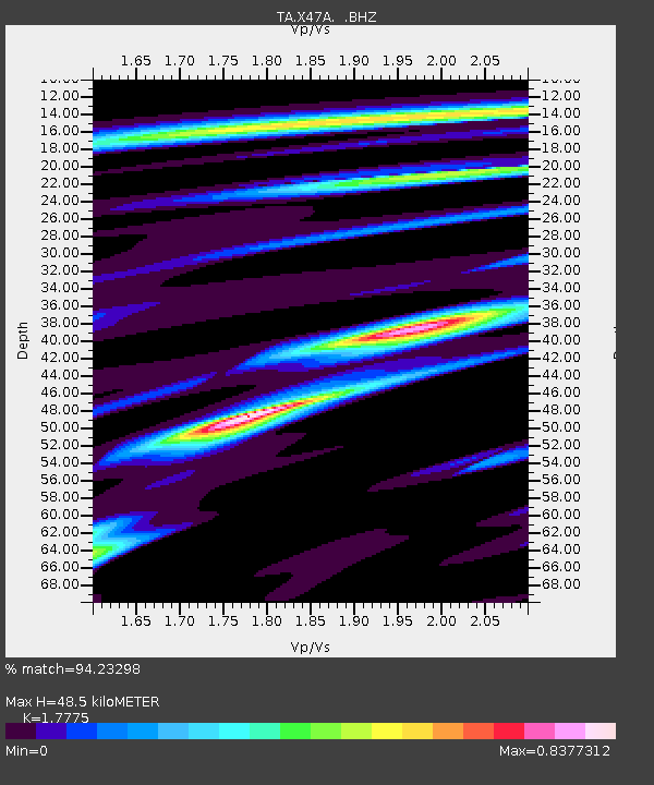
X47A Russelville, AR, USA - Earthquake Result Viewer

Earthquake location: Fox Islands, Aleutian Islands
Earthquake latitude/longitude: 52.6/-167.4
Earthquake time(UTC): 2012/08/10 (223) 18:37:43 GMT
Earthquake Depth: 13 km
Earthquake Magnitude: 5.9 MB, 6.2 MS, 6.2 MW, 6.2 MW
Earthquake Catalog/Contributor: WHDF/NEIC
Network: TA USArray Transportable Network (new EarthScope stations)
Station: X47A Russelville, AR, USA
Lat/Lon: 34.52 N/87.86 W
Elevation: 212 m
Distance: 57.4 deg
Az: 74.499 deg
Baz: 314.661 deg
Ray Param: 0.06349024
Estimated Moho Depth: 48.5 km
Estimated Crust Vp/Vs: 1.78
Assumed Crust Vp: 6.476 km/s
Estimated Crust Vs: 3.643 km/s
Estimated Crust Poisson's Ratio: 0.27
Radial Match: 94.23298 %
Radial Bump: 351
Transverse Match: 71.0128 %
Transverse Bump: 400
SOD ConfigId: 469095
Insert Time: 2013-02-22 06:08:59.638 +0000
GWidth: 2.5
Max Bumps: 400
Tol: 0.001

Signal To Noise

ChannelStoNSTALTA
TA:X47A: :BHZ:20120810T18:47:00.300022Z7.02637433.930589E-75.59405E-8
TA:X47A: :BHN:20120810T18:47:00.300022Z2.45553261.4559494E-75.9292613E-8
TA:X47A: :BHE:20120810T18:47:00.300022Z2.53770781.3868069E-75.4648016E-8
Arrivals
Ps6.1 SECOND
PpPs20 SECOND
PsPs/PpSs26 SECOND